Заглавная страница Избранные статьи Случайная статья Познавательные статьи Новые добавления Обратная связь FAQ Написать работу КАТЕГОРИИ: ТОП 10 на сайте Приготовление дезинфицирующих растворов различной концентрацииТехника нижней прямой подачи мяча. Франко-прусская война (причины и последствия) Организация работы процедурного кабинета Смысловое и механическое запоминание, их место и роль в усвоении знаний Коммуникативные барьеры и пути их преодоления Обработка изделий медицинского назначения многократного применения Образцы текста публицистического стиля Четыре типа изменения баланса Задачи с ответами для Всероссийской олимпиады по праву 
Мы поможем в написании ваших работ! ЗНАЕТЕ ЛИ ВЫ?
Влияние общества на человека
Приготовление дезинфицирующих растворов различной концентрации Практические работы по географии для 6 класса Организация работы процедурного кабинета Изменения в неживой природе осенью Уборка процедурного кабинета Сольфеджио. Все правила по сольфеджио Балочные системы. Определение реакций опор и моментов защемления |
I. The geography of the Russian Far EastСодержание книги
Похожие статьи вашей тематики
Поиск на нашем сайте Предисловие Учебное пособие «Российский Дальний Восток» предназначено для студентов 2 курса дневного отделения всех специальностей (кроме специальностей, углубленно изучающих курс английского языка). Цель учебного пособия – развить навыки устной речи, помочь студентам овладеть разговорной речью (как монологической, так и диалогической) по темам, связанным с географией, историей и экономикой Российского Дальнего Востока (Хабаровского края). Учебное пособие также может быть использовано для самостоятельной работы (4 раздел). Учебное пособие служит не только источником языкового и грамматического материала, но и учит студентов в работе с текстом различным видам чтения (ознакомительному, аналитическому, поиску в тексте определенной информации), прогнозированию содержания текста и общению по заданной теме. Лексика определяется тематикой. Учебное пособие состоит из 5 разделов: География российского Дальнего Востока, Хабаровский край, Экономика российского Дальнего Востока, тексты для дополнительного чтения, контроль знаний. Структура первых двух разделов стереотипна: - предтекстовые фонетические упражнения; - текст по заданной теме; - лексико-грамматические упражнения; - упражнения по развитию диалогической и монологической речи; - тематический словарь, предназначенный для активного усвоения. 3-й раздел, в дополнении к обобщающему тексту по экономике российского Дальнего Востока и лексико-грамматическим упражнениям к нему, содержит подробную информацию об отраслях экономики российского Дальнего Востока, включает диаграммы по экономике всех дальневосточных регионов России. Также в структуру 3-го раздела включена тема "Экономика Хабаровского края". 4-й раздел содержит дополнительный материал по географии и истории Дальнего Востока и может быть использован по усмотрению преподавателя. 5-й раздел состоит из нестандартных упражнений по контролю знаний по теме "Российский Дальний Восток (Хабаровский край)". Знание предложенных текстов поможет студентам вести беседу по заданным темам, расширит кругозор, поможет сделать сообщение по определенной теме. I. THE GEOGRAPHY OF THE RUSSIAN FAR EAST Ex. 1. Read the following words:
expanse, shrub, variety, to include, illiteracy, resources, coal, oil, consciousness, strait, deposit, to divide, to mingle, to be wiped, tapped, endangered species, coniferous, broadleaf, peculiar, rare, valuable, fur-bearing, indigenous, fowl, relict, inhabit, fauna.
Ex. 2. Learn the pronunciation: yew [ ] marten [ ] cedar [ ] weasel [ ] birch [ ] beaver [ ] spruce [ ] lynx [ ] ash [ ] roe-deer [ ] oak [ ] elk [ ] larch [ ] boar [ ] maple [ ] whale [ ] invertebrate [ ] walrus [ ] otter [ ] scallop [ ] mussel [ ] stork [ ] grouse [ ] oyster [ ] hawk [ ] erne [ ] heron [ ] algae [ ] alga [ ] cormorant [ ] zinc [ ] pheasant [ ] lead [ ] salmon [ ] ermine [ ] bream [ ] sable [ ] sturgeon [ ] prawn [ ] wolverine [ ]
Ex. 3. Read and translate the texts: II. THE KHABAROVSKY KRAI
Ex. 1. Learn the pronunciation: advantageous [ ] humidity [ ] alluring [ ] tributary [ ] estuary [ ] precious [ ] outward [ ] centigrade [ ] average [ ] vicinity [ ] relief [ ] ore [ ]
Ex. 2. Read and translate the text:
The Khabarovsky Krai
The distance from Moscow to Khabarovsk by rail is 8,533 km., while by air it is 6,075 km. The people of Khabarovsk are sure that clearly advantageous geographic location of Khabarovsk has, from the very start, determined the importance of the city as the centre of the Russian Far East. The Khabarovsky Krai (organized in October, 1938) extends from south to north for 1,780 km and from west to east from 125 to 750 km. Our closest neighbours on the russian side are the Primorsky Krai, the Amurskaya Oblast and Magadanskaya Oblast, the Jewish Autonomous Oblast, and the Republic of Sakha (Yakutiya), while the Nevelskoy and Tatar Straits separate us from Sakhalin Island. Our southern foreign neighbour is China. The area of the Khabarovsky Krai is 787,600 sq. k.m., while the total length of the coastline of the Sea of Okhotsk and that of the Sea of Japan is 2,500 km, i. e. 4,5 % of Russia's entire territory. It includes 17 administrative districts (rayons). The Khabarovsky Krai lies in the continental climatic zone and is characterized by winter and summer monsoons. This means winters tend to be quite mild with a lot of snow and average temperatures of about 22-25 degrees Centigrade below zero. This is not as cold as Siberia, where -30 is a general average temperature. The summer is characterized by high humidity and heavy rainfalls. The July average is + 24 degrees. Climate conditions vary significantly from the north to the south and depend on the land relief and sea vicinity. Most of the Khabarovsk area is mountainous. The mountains form extensive ranges, the names of which are both enigmatic and alluring: Sikhote-Alin, Badzhal, Khingan, and the like. They are rather high (the maximum height is 2,933 metres), impressive, and are cut by watercourses. The pride of this is the Amur-river that flows across 6 districts – the Khabarovsk, Nanay, Amur, Komsomolsk, Ulchsky, and Nikolayevsk Districts. The Ussuri River flows through the Bikin, Vyazemsky, and Lazo Districts. Other major rivers include the Tunguska (Khabarovsky District), the Gur (Komsomolsky District), the Bureya (Verkhnebureyinsky District), the Okhota (Okhotsky District), the Uchur (Ayano-Maisky District), and the Amgun (Polina Osipenko District). “Amur” – is the world’s 8th longest river with headwaters in Mongolia and China with its tributary streams the total length of the river is 4, 444 km. Near Khabarovsk the Amur river is over 1 mile wide. The distance from Khabarovsk to the Pacific Ocean is about 600 miles, and it takes 44 hours to reach the estuary of the Amur by ship. In its estuary the Amur river is about 30 miles wide and almost 300 feet deep. But anyway only the 15 hundred miles of the Amur river are navigable for approximately 6 months a year. The Amur river carries cargo to the numerous sea ports of this country and abroad. The Amur Shipping Company has recently expanded the geography of its outward voyages. A few river ports have been additionally opened to be visited by the Chinese ships. The administrative centre of the Khabarovsky Krai is the city of Khabarovsk that covers almost 400 sq km and stretches along the right bank of the Amur-river for 45 km. The population of the Khabarovsky Krai is under 2 million, and about 620 thousand people live in Khabarovsk (in other words – slightly more than in Washington D.C.). Khabarovsk is an important point on the Trans-Siberian Railway (it takes 6,5 days to get to Moscow). It also has Russia’s third largest airport, offering direct flights to Harbin, Guanchzou, Seoul, Niigata, and other international destinations. It is also the Head-quarters of the Russian Far Eastern Military Region. The Khabarovsky Krai holds an important place in the Russian Far Eastern economic region and even in Russia because of such natural resources as timber, precious species of fish and fur animals, ores of ferrous, non-ferrous and precious metals, water resources and others.
Ex. 3. Translate the following words and word combinations:
clearly advantageous, from the very start, closest neighbours, tend to be quite mild, coastline, headwaters, cargo, slightly more, Far Eastern Military Region, to be visited by, outward voyages, fur animals, ferrous and non-ferrous metals.
Ex. 4. Match the adjectives on the left with the nouns on the right:
Ex. 5. Insert prepositions where necessary:
1. The distance from Moscow to Khabarovsk … rail is 8, 533 km. 2. The Khabarovsky Krai extends from south to north … 1, 780 km and from west to east … 125 … 750 km. 3. Our closest neighbour … the Russian side are the Primorsky Krai, the Amurskaya and Magadanskaya Oblasts, the Jewish Autonomous Oblast, the Republic of Sakha, while the Nevelskoy and Tatar Straits seperates us … Sakhalin Island. 4. The summer is characterized … high humidity and heavy rainfalls. 5. Climate conditions depend … the land relief and sea vicinity. 6. Amur is the world’s 8th longest river … headwaters in Mongolia and China. 7. The Khabarovsky Krai holds … an important place in the Far Eastern Economic region.
Ex. 6. Insert the words from the text:
1. The people of Khabarovsk are sure that clearly … geographic location of Khabarovsk has determined the importance of the city as the centre of the Russian Far East. 2. The Khabarovsky Krai … from south to north for 1,780 Km. 3. Our closest … are the Primorsky Krai, the Amurskaya and Magadanskaya Oblasts, the Jewish Autonomous Oblast, the Republic of Sakha. 4. The Tatar Strait … us from … Island. 5. Our southern … neighbours is China. 6. The Khabarovsky Krai lies in … climatic zone and is characterized by winter and summer …. 7. The summer is characterized by high … and heavy …. 8. In winters … temperatures are – 22 - 25 degrees …. 9. Most of Khabarovsk area is …. 10. The Amur river … across 6 districts. 11. “Amur” is the 8th longest river with … in Mongolia and China. 12. The total … is 4, 444 km with its … streams. 13. It takes 44 hours to reach … of the Amur by …. 14. Only 15 hundred miles of the Amur are …. 15. The Amur Shipping Company has recently expanded the geography of its … voyages. 16. The city of Khabarovsk … along the right bank of the Amur-river for 28 miles. 17. Khabarovsk has Russia’s third largest …. 18. It is also … of the Russian Far Eastern Military Region. 19. Khabarovsk is an important … on the Trans-Siberian Railway. 20. The Khabarovsk airport offers flights to international destination. Ex. 7. Prove the statements:
1. The Khabarovsky Krai has advantageous geographic location. 2. Climate conditions vary significantly. 3. The Khabarovsky Krai lies in the mountainous area. 4. The Amur-river is one of the important rivers of the Russian Federation. 5. Rich natural resources attract attention to the Khabarovsky Krai.
Ex. 8. Answer the questions:
1. What is the distance from Moscow to Khabarovsk by rail/by air? 2. When was the Khabarovsky Krai as the administrative unit organized? 3. What are the neighbours of the Khabarovsky Krai? 4. Is the territory of the Khabarovsky Krai large? 5. Why is the climate of the Khabarovsky Krai peculiar? 6. Does the Amur-river play an important role for the Khabarovsky Krai? 7. What are the advantages of the geographical position of the Khabarovsky Krai? What role do they play for the development of the Khabarovsky Krai? 8. Is the Khabarovsky Krai rich in natural resources?
Ex. 9. Make up your own topic according to the plan:
1. Advantageous geographic location 2. Neighbours 3. Climate conditions 4. The major rivers and mountainous ranges 5. Rich natural resources
Ex. 10. a) read and translate the dialogue:
- Now we are going down the street of T.Shevchenko, leading to Lenin Stadium, the central stadium of the city. - I see the Fine Art Museum and Concert Hall and what’s this? - This is the State Museum of the Far East. - The building seems to be old. - Right. The Local Lore Museum was founded in April, 19, 1894 on the initiative of the Russian Geographic Society. - The museum is named after N.I. Grodekov. What was he? - N.I. Grodekov was the governor-general of the Far East. He worked and lived in Khabarovsk. Grodekov was honoured citizen of Khabarovsk who took part in the foundation of the museum. - I heard that a well-known scientist and writer V.K. Arsenyev lived here. Was his activity also connected with the museum? - Of course, it was. V.K. Arsenyev was the director of the museum from 1910-1918 and 1925-1926. He took part in the organization of the museum and in collecting of its exhibits. - How many departments are there in the museum? - Let’s see. First of all, nature department which features geography of the Khabarovsky Krai, its mineral resources, unique flora and fauna. On the second floor there are etnography department dating back to the turn of the 20th century and tracing the natural and cultural history of the indigenous people; the department of the political movements including the exposition "The Civil war and military conflicts" with its panorama of Volochaevskaya battle; the department devoted to the Russian pioneers and the history of settlement of the Russian Far East. Besides, we have different temporary displays on the second and third floors. Would you like to listen to one of the lectures offered by the museum to its quests? - With pleasure. Can we do it right now? - Sure. Let’s go.
b) Continue the talk between the citizen of the city and its quest or act out the above dialogue. Vocabulary:
Advantageous [ ] – выгодный to extend – простираться humidity – влажность average – среднее (ий) vicinity [ ] – окрестности range – (горная) цепь enigmatic – загадочный alluring [ ] – соблазнительный watercource – река, ручей, поток headquarters [ ] – главное управление, штаб tributary stream – приток estuary – устье approximately – приблизительно destination – место назначения headwater – истоки precious [ ]– ценный, драгоценный (металл) timber – древесина ore [ ] – руда centigrade [ ] – по Цельсию outward – внешний OF THE RUSSIAN FAR EAST Resource Potential The Russian Far East is endowed with rich natural resources unique in many respects. It has Russia’s largest reserves of some traditional raw materials and minerals: antimony, boron, tin (up to 95% of national reserves), fluorspar and mercury (up to 60%), about 24% of tungsten and 8-10% of iron ore, lead, sulfur, apatite. There is the world’ largest diamond province located in the northwest of Sakha, which collectively contain more than 80% of Russian diamond reserves. Proved reserves of iron ore in south Yakutia amount to over 4 billion tons (80% of regional reserves). Considerable iron ore reserves are also found in Jewish Autonomous Oblast. Major coal deposits are found in Lensky and Yuzhno-Yakutsky areas (Sakha), the Amurskaya Oblast, Primorye and the Khabarovsky Krai. The RFE is one of Russia’s most important gold producing areas. Vein and placer deposits and found in Sakha, Magadanskaya and Amurskaya Oblasts, the Khabarovsky Krai and Kamchatka. Fuel and energy resources include oil and gas, brown and black coals. Main oil and gas reserves are found in two vast oil and gas provinces: Sakhalinskaya (major offshore gas and oil fields) and Leno-Viluyskaya (natural gas). The last one contains over 60% of RFE’s natural gas reserves. Nonmetallic mineral reserves are also available: limestones, marl, refractory clays, quartz sands, sulfur, graphite. Mica deposits are found in the upper reaches of the Aldan River. Mineral waters suitable for health remedial uses are found in all RFE administrative territories. Best-known are mineral spas in Shmakovka and Kuldur. There are geysers associated with volcanic activity on Kamchatka. The water of hot springs contains zinc, antimony, arsenic and has a remedial significance which opens up good opportunities for establishing resorts. The most important biological resources are fish and seafood. There are the world’s largest stocks of salmon and codfish (cod, Alaska pollack, ‘navaga’ cod, hake) in the Pacific seas surrounding the Russian Far East (Bering Sea, Sea of Okhotsk, Sea of Japan), which are also inhabited by seals, walruses, fur seals. The region’s forest resources account for 35% of the national total.
Agriculture The region’s farming sector generates 5% of Russia’s gross agricultural output. The input of individual RFE territories in agricultural production depends on differing natural and climatic factors. Leaders in the farming sector are the Amurskaya Oblast (23%) and Primorye (18%) followed by Sakha and the Khabarovsky Krai (less than 18% each), Kamchatka (10%), Sakhalin (8%), Jewish AO (about 3%). The region’s geographic position and related environmental conditions constrain the normal development of agriculture in the most part of its territory. Land area amounts to more than 600 million ha and is composed of three main types: forested land (44%), reindeer pasture (30%) and barren land (22%). Farm land accounts for no more than 1% of the region’s land resource. The climate of the northern RFE is suitable for cultivating potatoes and some less delicate vegetables as well as for developing dairy farming. Also, crops are grown in hot-houses. More than 55% of agricultural production is concentrated in the central and southern parts of Primorye, in the Amurskaya and Jewish Autonomous Oblasts and in the south of the Khabarovsky Krai. Still, these areas have inadequate conditions for satisfying local demand for basic food products, and the farming sector here is specialized in the production of non-transportable (perishable) products. Natural conditions are suitable for growing grain (wheat, barley, oats, corn), vegetables, rice. Many experts assess the region’s potential for crops cultivation as considerable and explain the low productivity of this sector by insufficiency of capital investments. Animal husbandry accounts for more than 60% of the total agricultural output. This branch includes the breeding of dairy and beef cattle, swine, poultry (broilers and egg-layers), reindeer and deer for antlers, apiculture; private households breed also rabbits and sheep. Unlike crops production, the output of animal husbandry is distributed proportionately to the numbers of population in individual RFE territories. Commercial animal husbandry is based on large mechanized farms, including fur animal breeding farms and nurseries.
Industry The proportion of the secondary sector (processing industries) in the RFE economy has decreased during 1990s, it was undergoing structural changes accompanied by more than two-fold drop of production in absolute terms. The percentage of machine-building and metalworking has decreased from 15.5% to 8.4%, while that of the energy and fuel branches has grown from 3.5% to 25.1% and from 3.8% to 11.5% respectively. The share of nonferrous metallurgy went up by 47%, and that of food processing, logging, woodworking and building materials reduced. These structural changes have been caused by the unevenness of the reduction of real production volumes in respective branches. The fuel and energy complex of the Russian Far East is composed of the fuel industry (oil, gas and coal production), oil processing industry, energy and heat providers. It is the region’s largest industrial complex and generates about 35% of the total industrial output. Recession in the coal industry corresponded to the nationwide decline - production volume fell from 51.6 to 31.6 million tons. The Trans-Baikal showed a better dynamic of coal production: in Buryatia decline was only 7.2% and in the Chitinskaya Oblast 18.4% growth was registered. Trans-Baikal inclusive, the Russian Far East’s total coal production volume amount about 19% of the national total. Oil production reached 1.78 million tons in which was an 88% increase on 1990. Natural gas production amounts to 3.4 billion cubic meters. Other commercially available energy resources are hydropower and nuclear power. There is great potential for use of non-traditional sources of energy which might fully satisfy local demand. However, they generate only less than 0.1% of total electricity output. The structure of energy production is dependent on the available resources: about 70% is derived from coal, oil, natural gas and hydropower. The region’s two oil refineries are found in the Khabarovsky Krai (Khabarovsk and Komsomolsk-on-Amur). The bulk of oil is delivered from West Siberia by rail. Oil from Sakhalin comes to Komsomolsk-on-Amur by pipe (some 10%). The depth of oil refining is rather low: 60-65%. Electric energy is produced by general-use, power plants generating more than 93% of electricity and local plants. There are several joint-stock companies providing and conveying energy and a special division, VostokEnergo, Amurskaya, Dalnevostochnaya and Khabarovskaya energy systems, Yuzhno-Yakutsky energy area and the eastern part of Chitinskaya energy. Heat energy is produced by heat-and-power stations and boilerhouses. The total length of main heat and steam lines was exceeding 11,000 kilometers and the number of boiler-houses was above 15,000. Power plants provide about 35% of heat, the rest is produced by boiler-houses. Basic type of fuel for boiler-houses and plants is coal, although some regions (Kamchatka, Primorye, the Khabarovsky Krai) use much fuel oil and diesel oil. RFE is Russia’s largest fish and seafood producer. Fish processing is developed mainly in the onboard form. The fishery complex is composed of fish and seafood catchers, processors, specialized facilities and services, fish stock reproduction organizations. Close linkages interconnect different parts of this complex with each other and with other economic sectors. It is serviced by a large number of specialized branches such as shipbuilding, ship repair, ports, transport and reefer fleet, manufacturers of fishing gear, packing materials, etc. Auxiliary services (procurement, sales, communications, construction and others) provide support both to fish producers and specialized services involved. The forest complex includes forestry, logging, woodworking and pulp-and-paper branches. This complex accounts for 5.4% of industrial production. The pulp-and-paper industry is developed poorly and represented by several mills on Sakhalin, in the Khabarovsky Krai, the Jewish Autonomous and Amurskaya Oblasts. Traditionally, timber processing in the Russian Far East falls behind the scope and dynamic of logging activities and the bulk of timber is exported in round logs; in the years of economic reform it has dropped two-three times. Major woodworking centers are Birobidzhan, Blagoveshchensk, Vladivostok, Komsomolsk-on-Amur, Khabarovsk. The chemical and petrochemical sector includes ore mining and dressing enterprises and facilities manufacturing industrial and household chemical products, varnishes and paints, plastic goods, glass reinforced plastic, etc. It accounts for only 0.8% of the RFE’s total industrial output. Major plants are found in Primorye and the Khabarovsky Krai. Leading machine-building branches are ship repair, manufacture of electric engineering and other equipment, machine tools, etc. The sector reduced its output 1990-97 due to declining demand, low competitiveness with imported products, high transport tariffs. Its share in the region’s production volume fell from 15.5% to 8.4%. One of major machine-building centers is Khabarovsk. The machine-building sector of the Khabarovsky Krai accounts for 30% of total industrial output. In other RFE regions, its percentage in gross output is insignificant: Primorye - 6.4%, the Amurskaya Oblast - 3.4%, Sakha - 1.5%, Sakhalin - 1.4%. Machine-building plants manufacture diesel engines, overhead cranes, marine machinery, cast molding equipment, metalcutting machine tools, instrumentation, tools and other products. The proportion of ship repair has considerably grown in the past decade and reached 40% of all machine-building operations. Machinery repair facilities are available in all regions. The light industry is represented by textile, knitting, footwear, leather making and other facilities deployed mainly in large and mid-size cities. Its percentage in total industrial output has sharply dropped in 1998 which reflects a more deeper recession in this sector in comparison with an overall dynamic of the region’s industry. This reduction is largely explained by low competitiveness of the bulk of produce and re-orientation to imported goods. The food industry sector accounts for a modest portion of the RFE’s industrial output. The rate of reduction in the food sector exceeded an average one for the region’s industry as a whole. By 2000, this percentage was 20%, with in-kind product volume having grown by 17% in the same year. Due to the insufficiency of local food production and huge competitive pressure of imported products, the Russian Far East was importing great amounts of food stuffs from overseas. Construction
Construction is one of investment-attracting economic sectors having extensive inter-relationships with other branches. Its percentage in the region’s total GDP is 5%. The important role of extractive industries requires continuous investment in new facilities which makes an objective factor for developing the construction sector. Nevertheless, the volume of construction works has considerably dropped during last 10 years; for instance, reduction in housing construction was 20-30% which had its effects on the building materials industry and the total value of performed construction works. The RFE’s total industrial output dropped from 6.5% to 1.6%. Still, the dynamic differs from region to region: in some areas the peak of recession in the construction sector was passed in 1998 and real volume of operations is growing.
Transport Transport plays an important role in RFE economy due to its geographic position, economic specialization and specifics of production. It accounts for over 10% of the region’s total GDP. Transport costs have become a principal factor in the disintegration of the regional economy from the central part of Russia. Specific of the transport sector is orientation at cargo transit which accounts for more than 80% of rail and sea traffic. It is mainly foreign trade flows from other Russian regions and CIS states to Asian Pacific countries. The Russian Far East uses all existing transport modes, but the principal role belongs to railway transport, which handles up to 80% of cargo traffic. Main railroads pass across the central and southern parts of the region. They are eastern sections of the Trans-Siberian and Baikal-Amur railroads. The largest railroad is Trans-Siberian. The termini of the Baikal-Amur and Trans-Siberian lie in sea ports: Vanino, Vladivostok, Vostochny, Zarubino, Nakhodka, Posyet, Sovetskaya Gavan. RFE railways are connected with China’s northeast provinces in several points. The sea transport accounts for 15% of the region’s freight traffic. The total number and deadweight of ships considerably decreased in the last years. The bulk of the fleet is dry cargo carriers (container ships, reefers, timber carriers, bulk carriers, ferryboats, etc.), the rest is tankers and icebreakers. More than 50% of foreign trade cargoes are carried by foreign ships among which there are many Russian ships flying "convenient" flags. There are more than 30 sea ports scattered along the RFE’s coast, the largest of which are ten major ports providing round-the-clock services: in Primorye - Vladivostok, Vostochny, Nakhodka, Posyet, Khasansky (Zarubino), in the Khabarovsky Krai - Vanino, on Sakhalin - Kholmsk and Korsakov, in the Far North - Magadan and Petropavlovsk- Kamchatski. These ports handle over 90% of the region’s cargo turnover. The river transport is represented by major shipping companies, river ports, ship repairing and shipbuilding yards, small agency companies. The river fleet is composed of ships of various designations, including general-purpose multi-use ships of "river-sea" type capable of navigating both along inland waterways and on the high seas. Amur Shipping Company handles traffic in the Amur Basin area. Total length of navigable waterways is about 5,000 km. The largest river ports having railway access are Khabarovsk, Komsomolsk-on-Amur, Blagoveshchensk, Svobodny, Poyarkovo. The air transport plays a critical role in the life of the Russian Far East, especially in outlying areas of the Far North where there are no railways and navigation period is short (Chukotka, Magadan, northern Sakha). It connects the region with the rest of Russia, handles intra-regional traffic and provides international linkages. The airports of all RFE administrative centers are open to international flights. Since 1991, the volume of international traffic (USA, South Korea, Australia and others) have accounted for a considerable portion of passenger traffic. The road transport plays an important role in passenger and cargo traffic and in some areas (lacking railways) is a predominant transport mode. Thus, on Kamchatka and the Magadanskaya Oblast its percentage in the total volume of traffic exceeds 70%. The road infrastructure is rather developed. Total length of paved automobile roads is about 25,000 km, of which more than 70% is found in the south of the region. Okrug Okrug
- 51.4 % - food industry metallurgy - 46.7 % - non-ferrous - 41.5 % - non-ferrous metallurgy - 30.5 % - electric energy - 5.7 % - electric energy - 16.3 % - food industry - 1.3 % - fuel complex - 6.5 % - fuel complex - 0.05 % - other industries - 0.1 % - other industries Jewish Autonomous Oblast Republic of Sakha (Yakutiya)
- 30.4 % - construction metallurgy - 72.7 % - non-ferrous - 17.9 % - electric energy - 11.2 % - fuel complex - 13.2 % - machine building - 11 % - electric energy - 12.8 % - forest complex - 2 % - food industry - 10.4 % - light industry - 1.1 % - other industries - 7.2 % - food industry - 0.9 % - construction - 3.4 % - other industries - 0.8 % - construction - 2.7 % - non-ferrous metallurgy - 0.3 % - machine building - 1.9 % - fuel complex ABOUT THE RUSSIAN FAR EAST
Went on their travels? In 1640, the Cossacks from Moskvitin’s detachment were first Europeans to come to Sakhalin. In 1648, Cossack Semyon Dezhnev was the first to sail through the strait which separates Asia from America. In the same year, Fedot Popov, who took part in Dezhnev’s march, was the first Russian to come to Kamchatka. In 1651-1653, Yerofei Khabarov, a former peasant and later a seafarer, drew a detailed map of the upper and middle reaches of the river Amur, almost up to the present city of Khabarovsk. For a long time this map was the main source of drawing maps by Russian and foreign geographers. In 1697, Siberian Cossack Vladimir Atlasov gave the first information about Kamchatka and the Kurile Islands (Fedot Popov died from scurvy in Kamchatka before he could tell the government about his discovery). So the Russian pioneers also made their contribution to the great geographical discoveries of the 15th-17th centuries which is shown by geographical names. For example, the northeasternmost point in Asia (Cape Dezhnev), a range in the Chukchi Peninsula and a bay in the Bering Sea were named after Dezhnev. A tributary of the River Kamchatka was named Fedotovshchina (after Fedot Popov). One of the largest cities in the Far East was named after Khabarov – the city of Khabarovsk. One of the Kurile Islands was named after Atlasov.
Explain the dates:
1640, 1648, 1651-1653, 1697.
Mighty Amur Khabarovskiy cliff and its vicinity, is where the Far Eastern center began its growth, as it was rendered habitable long ago. We know practically nothing about its ancient and the earliest inhabitants. We can assume that many tribes and nations lived there during past millenniums. There was a Nanayan nomad camp at the place of the future Khabarovsk before Russian explorers came. Aborigines lived on both banks of Amur. Signs on old geographical maps show their settlements. The famous researcher of Siberia and the Far East, Richard Karlovich Maak, who participated in the first Amur floating down this great Far Eastern river in 1855, described the future Khabarovsk vicinity. “There is an immense area of water, merging with the horizon in front of us. The view is wonderful: the sun is brightly reflected on absolutely calm water, filling it with golden light, there are sea-gulls in the air, our eyes meet only mirrors of water and clear sky”. He also told about cliff Byri with small nearby village. “Rocky ledge Byri”, mentioned by Maak, is the Khabarovskiy cliff. Maak was the first Russian and European scientist, who described the Amur, its banks and closest vicinity, the wealth of local nature, the people and their business. Recordings in his diary of July, 1885 are considered the first scientific-cognitive reporting about the location of the future town, which would appear a hundred years later on the Amur bank and occupy 50 kilometers. One evening he went back along the bank to cliff Byri to visit the village of natives, located near it. He wrote: “During this trip I was certain that Amur is rich in fish, I shot some sturgeons with my gun; huge sturgeons jumped out of the water and disappeared again, flapping their wide tails. Sturgeons and a lot of other fish were swimming near our feet between the stones, they were playing under the sun, splashing the water and leaving quickly disappearing circles on the surface of the river”. The scientist observed this pageant near the present-day plant “Daldiesel”.
Read two quotations from the diary of R. K. Maak, traveler-naturalist, geographer and geologist: “… Перед нами открылась необозримая площадь воды, сливавшаяся с горизонтом. Вид был прекрасный: солнце ярко отражалось в совершенно покойной воде, обливая ее золотистым светом, в воздухе вились чайки, и взоры встречались только с зеркалом воды и с ясным небом”. “Во время этой прогулки я имел случай убедиться, как обилен Амур рыбою, и убил из ружья несколько осетров; огромные калуги беспрестанно выскакивали из воды и снова скрывались, взмахнувши своим широким хвостом; у наших ног, между каменьями, плавали осетры и множество различной рыбы играло на солнце, беспрестанно всплескивая воду и оставляя на поверхности реки быстро расходившиеся круги”.
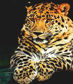
Far Eastern leopard
The Amur leopard (Panthera pardus orientalis Schlegel) is a rare, threatened subspecies. Its natural habitat covering Northeast China, Korean Peninsula, and the southern part of the Primorsky Krai, Russia, by now has shrunk to a dangerously small area. There are only a few leopards (not more than two dozen) left in China, while in Korea they allegedly disappeared altogether. They can still be found only in the southwestern part of the Primorsky Krai, Russia. According to the survey of the leopard populations recently conducted by wildlife biologists V. Korkisliko and D. Pikunov there, are still 25 to 30 leopards left in the Primorsky Krai, Russia, with some of them having their habitats extending into the Chinese territory. In the early 20th century, the leopard was frequently spotted by local people on the spurs of the Sikhote Alin mountain complex and to the southwest of Lake Khanka, but with the passage of years wildlife biologists failed to spot the leopard there. The harsh winters and depletion of game were, the most significant factors that had dwindled the роpulations of the Amur leopard in the past and during past several decades the expansion of economic activity of man has displaced the leopard from its traditional habitat and has driven it to the brink of extinction… There has not been put a stop to poaching not only of leopard's prey, such as roe and Japanese deer, raccoon dogs, badgers, and hares, but the leopard itself As concerns hunting the Amur leopard, it is not a very difficult task: virtually any pack of hounds are able to make not only a young leopard, but an adult one as well climb a tree; hunger drives it to try any meat bait and as a result it can easily fall into a trap. And that is what poachers make use of. The only wildlife sanctuary where the Amur leopard can breed is Cedar Creek Valley located in the southern part of the Primorsky Krai, Russia. But even this sanctuary has become so small (about 18,000 ha) that it can no longer play a critical role in the conservation of this graceful big cat. Outside the wildlife sanctuary Cedar Creek Valley the only refuge for the leopard in the Primorsky Krai, Russia, remains a small area of about 200 kilometers between the Razdolnaya River and the Posyet Gulf. There the leopard keeps to a diminishing pristine, mountainous belt of coniferous-broadleaved and hardwood forests along the border with China, primarily on the Borisovsky Plateau. Hillsides and plateaus facing the rivers have numerous cliffs with convenient recesses and caves that are indispensable for leopards as shelter in bad weather as well as for breeding. The area is teeming with roe deer and is rather far from human settlements; in the forest belt along the Chinese border one can find large herds of Japanese deer. These ungulates are the principal prey for the leopard thanks to whom it can survive the harsh winters. Of great help for the leopard are Manchurian hares, raccoon dogs, badgers, and some other game living in that area. The leopard is perhaps the most beautiful, graceful, strong, and daring of all the big cats and at the same time it is a very cunning predator. Its tawny yellow fur decorated with dark spots clustered together in rosette shapes helps conceal the animal in its natural surroundings, be it a taiga forest, grassland, or a glade covered with yellowed leaves. The leopard has strong eyes, acute hearing, and a fine of smell. Unhurried when content, it can bound with great speed, is a good climber, and is unbelievably strong: carcasses of prey weighing from 35 to 68 kilograms have been found in tress 4 to 6 meters above ground where a leopard had carried them. As compared with the tiger, it is not very big: a female may weigh about 50 kilograms; a male: up to 70 kilograms. It feeds upon any animals it can overpower, but generally preys on the smaller and medium-sized ungulates. Bears
Brown bear is one of the most widespread, well-known and popular animals in Russia. Generally considered the national symbol, it was almost unanimously voted a mascot of 1980 Moscow Olympics. Big and peaceful bear is a favorite character of fairy tales and cartoons. Few people realize that it is the very same species as the much-feared grizzly bear of North America. Although on average bears kill ten people per year in Russia (much more in the years of poor pine nuts crop in Siberia), it is not unusual to see tourists routinely using bear trails, or village girls gathering berries almost side by side with brown bears. If such an idyllic scene happened in America, the bear would almost certainly be shot, and the girls would have to endure a three hour-long safety talk by park rangers. Unfortunately, this almost-peaceful coexistence of bears and people, quite common in remote areas of Russia only two decades ago, is now rapidly becoming a fairy tale itself. Poaching for bale, fat and skins has severely depleted bear populations in all more or less accessible parts of the country It is believed that Ursus arctos colonized America from Asia. Not surprisingly, brown bears of the Old World show much higher diversity in appearance and behavior than their descendants in the USA and Canada. It is possible that this species is undergoing further speciation before our very eyes. Unlike in North America, where brown bears seem to prefer open landscapes (grasslands, Alpine meadows and tundra), in Eurasia they inhabit mostly dense forests, although they were probably more widespread in grasslands and even deserts in the past. One possible reason for this difference is that the particular population that invaded America thousands of years ago was tundra-adapted. In fact, the Chukchi Peninsula on the Asian side of the Bering Strait is the only place in Asia where brown bears live year-round in lowland tundra. Another possible explanation is that in America, dense forests are occupied by American black bear (U. americaniis). Its Asian counterpart, the Himalayan bear (U. tibetanus), is limited in its distribution to hardwood forests of Eastern Asia and to mountains of the northern part of Indian Subcontinent. If the two species do coexist (such as in the Ussuriland, the southernmost part of the Russian Far East), brown bear seems to prefer high-elevation coniferous forests and Alpine areas. The most widespread form of brown bear in Eurasia is "common" brown bear, U. a. arctos. It once occurred from Britain to Transbaikalia, and from Northern Scandinavia to the grasslands of Southern Ukraine and Northern Kazakhstan. Now only a few relict populations survive in Southern and Central Europe, and in the grasslands there are no bears at all. Bears are also gone from hardwood forests around Moscow and other major cities, but they are still present throughout the boreal forest zone from Norway to Yakutia. Within this huge area, they look more or less the same, although east from the Urals one will find a higher percentage of light- or reddish-colored bears. Research has shown that bears of the Alps and other European mountains are genetically distinct from those of taiga forests. There are also differences in their behavior, probably caused by varying levels of hunting pressure. In Europe (including European Russia, where bears were almost wiped out by trophy hunters prior to the 1917 revolution), they are typically strictly nocturnal, and seldom attack people or livestock. In many areas of Western, Southern, and Central Siberia, as well as in Northern Mongolia, bears depend heavily on Siberian pine (Pinus sibirica), known locally as "cedar". If its mast fails, starving bears start killing livestock, attacking people, and often do not hibernate - they wander around in deep snow until they starve to death or manage to kill a cow or a moose. Such shatun (wanderer) bears are responsible for most bear-caused human fatalities in Russia. It is believed that bears of Transbaikalia (sometimes known as "anteater bears" for their heavy use of Formica rufa ants for food) are more aggressive towards people than those of other parts of Siberia. One possible reason is that in Eastern Siberia, winters are very dry, with little snow cover, so bears are forced to "wake up early in spring, and have to hunt to survive until May, when young vegetation appears.. There were documented cases of Transbaikalian bears becoming "professional" man-eaters, with two animals killing more than 12 people each. Bears known as U. a. ognevi, that live east from the Kolyma River, are generally small, light-colored and relatively non-aggressive. They feed mostly on berries, because the only tree in the area is Dahurian larch (Larix gmelini). They tend to live above the timberline (which is less than 500 m above sea level in the area), or in Arctic tundra further North. Giant bears (U. a. piscivorus) of the Kamchatka Peninsula and Paramushir Island are very similar to Kodiak bears of Alaska, but tend to be darker. They also depend heavily on salmon, and are considered non-aggressive, although some unprovoked attacks do happen. They have interesting behavioral patterns - some of them even learn to kill sea otters on rocky shallows. Kamchatka used to have almost as many bears as all of Siberia, but recent plague of Japanese, American and European trophy hunters, as well as local poachers, has brought their numbers to one-fifth of what they used to be. On the Koryak Highlands, north from Kamchatka, these bears interbreed with small ognevi subspecies, but it looks like both prefer to breed with their own.
Another subspecies, U. a. manchuricus, inhabits the coast of the Sea of Okhotsk, Amur Basin, Sakhalin Island and Ussuriland. It once occurred in North Korea and Northeastern China, but is now almost extinct there. These animals are large (some were documented killing tigers), and utilize a great variety of food, from salmon to wild grapes. Interestingly, local hunters believe that there are three species of bears in the area: brown bear, Himalayan bear (locally called "white-breast" for characteristic V-shaped mark on its chest), and black bear, which is said to be the largest and most carnivorous of all three. The analysis of bear attacks on people and observed cases of bear predation on livestock and wild ungulates seems to confirm that all meat-eating individuals are large and dark-colored, and almost all of them are males. It is possible that this population is evolving towards separating into two species. But it is also possible that these bears are a mix-up of two races, one originating from Siberia or Central China and another - from Japan. Brown bears U. a. yesoensis of Hokkaido and the two southernmost Kuril Islands are said to be extremely dangerous. On a 100 mile-long Kunashir Island, where a few hundred people coexist with two hundred bears, bear attacks happen almost annually. These bears have unusually narrow skull and almost always show a reddish collar or spots around the neck. Answer the questions:
1. Animals of what climatic zones live in the Russian Far East? 2. Can you name the representatives of arctic fauna? 3. What endemic animals do you know? 4. Is the Far Eastern fauna rich in fur-bearing animals? 5. What sea animals live in the Pacific Ocean? 6. What are the subspecies of the bear? 7. Can you name any endangered animals and birds? 8. What hoofed animals live in the Russian Far East? 9. Are there many predator species and birds of prey in the Far East? 10. What do you know about the wild world protection? 11. Make a report about: any far eastern animal, or nature protection in RFE. Kunst and Alberts
Vladivostok, 1864. The two courageous young Germans Gustav Kunst and Gustav Alberts ventured to start their own business at the end of the Far East of Russia. The risk was high. To address the local situation, the entrepreneurs organized general trade. The local people were happy to buy everything they needed in one store: shoe polish, combs, plates, textiles, kerosene, soap. It was decided to deliver goods via Chinese ports. The company chartered vessels to ship goods to Vladivostok and exported seaweeds that the Chinese got on the coast. In the early 80-s regular voyages of the Voluntary Fleet vessels to Vladivostok were started. That allowed to open procurement offices in Europe: Odessa, Moscow, St. Petersburg, Warsaw, Hamburg, Munich, and later in the Asian market, the first in Kobe, Japan. With the establishment of the General-Governorship with a capital in Khabarovsk, the settlements and military posts were strengthened and new ones came into being. Very soon stores and business firms of “Kunst and Alberts” sprang in lots of them – in 1893-in Nikolaevsk, in 1894-in Alexandrovsk (Sakhalin), in 1895-in Khabarovsk and Blagoveschensk, in 1900-in Harbin, in 1913-in Obluchye. In 1902 the company invited G.R. Yunghendel, an experienced architect from Germany to design and construct buildings. All the magnificent buildings of the business firms, designed in the style of German baroque, were notable for their monumental design, refinement, and an attractive façade. The buildings, which are more than 100 years old, are still in use. There are legends about some of them, for e.g., the Mall (GUM) in Vladivostok, which used to be the head business firm of the “Kunst and Alberts” company. Some people believe that was the first supermarket in the world’s history. All building materials needed for its construction were brought in from Hamburg. There are wonderful stories about the business firm in Khabarovsk (the central grocer’s store). They tell us about the underground tunnels with rail tracks leading down to the lower bazaar, the deep basement-freezers. The partners believed that a business success depended on the working conditions and everyday life of the company’s employees. Single employees were provided with board and lodging. The benefit society established to address emergency situations, was of great help. A library, a bowling alley, a billiard-hall, a hospital – all this ensured adequate recreation. Boys working in the stores could attend evening courses, and in the summer they were sent to gymnastics classes organized by a local sports society. In 1880 the businessmen decided to come back to Germany. The company was managed by Adolf Datten, later in 1886 he joined the firm as the equal partner. In 1896 Gustav Kunst went out of business. In 1910 Gustav Alberts made his business over to his son Alfred Alberts. In 1913 proved to be triumphant year for the company. At the exhibition devoted to the 300 anniversary of the Romanov dynasty it built an exceptionally beautiful pavilion. Emperor Nikolay II rewarded A. Dattan with the Prussian Order of the Crown of the Sixth Degree for his contribution to the active development of trade in the Priamurskiy General-Governorship. The fateful 1914 began. A strict supervision was introduced over all German companies. Business competition had been always strong and some competitors wrote false papers to put the blame on the rival company. What really happened is not quite clear now, but the “Kunst and Alberts” activities were banned and the company’s managers were arrested. After a lot of investigations the company was allowed to resume its operations. During the Civil War it successfully fulfilled orders placed by the military department. On coming back from the exile, A. Dattan left Russia for Germany. The company and its branches were put in charge of the resident managers. In 1925 the company was deprived of its property, and it had to rent its own buildings from the municipal authorities. Five years later it had to stop its activities. A few decades passed, and in 1950-s the “Kunst and Alberts” firm was exculpated and the espionage charge was removed.
V. CHECK YOUR KNOWLEDGE
TEST "THE KHABAROVSKY KRAI"
1. What month was the Khabarovsky Krai organized in? a) August, 1945 b) November, 1917 c) October, 1938 d) February, 1922
2. What strait separate the Khabarovsky Krai from Sakhalin Island? a) Tatar b) Bering c) Nevelskoy d) Laperuzo 3. What rivers are the tributaries of the Amur? a) The Argun b) The Amgun c) The Aldan d) The Tumnin
4. The southern foreign neighbour of the Khabarovsky Krai is …. a) North Korea b) Japan c) China d) Mongolia
5. The oldest settlement of the Khabarovsky Krai is …. a) Nikolaevsk b) Okhotsk c) Ayan d) Khabarovsk
6. What city is famous for producing submarines? a) Khabarovsk a) Amursk b) Komsomolsk-on-Amur c) Nikolaevsk
7. What's the length of the Amur? a) 4400 km b) 3531 km c) 4444 km d) 4092 km
8. What climatic zone does the Khabarovsky Krai belong to? a) Monsoon a) Continental b) Sharply continental
9. What time zone does the Khabarovsky Krai lie in? a) The local time is +12 hours fast of the Greenwich Mean Time a) The local time is +11 hours fast of the Greenwich Mean Time b) The local time is +10 hours fast of the Greenwich Mean Time c) The local time is +9 hours fast of the Greenwich Mean Time
10. Khabarovsk has Russia’s third largest …. a) River port a) Railway station b) Airport
11. Most of the Khabarovsk Krai area is characterized as …. a) Plateaus b) Lowlands c) River valleys d) Mountainous
12. The sea port Sovgavan was earlier called …. a) Imperatorskay gavan b) Communistic gavan c) Japanese gavan d) Nevelskoy gavan
13. The largest port of the Khabarovsky Krai is …. a) De Kastri b) Vanino c) Okhotsk d) Nikolaevsk
14. The river Amur was discovered by …. a) Nevelskoy b) Muravyov c) Khabarov d) Poyrkov
15. The number fish species in Amur is more than …. a) 100 b) 80 c) 140 d) 50
16. The Khabarovsky krai takes 3 place in …. a) fishing b) gold-mining c) coal-mining d) oil-processing
CROSSWORD I
|
||||||||||||||||||||||||||||||||||||||||||||||||||||||||||||||||||||||||||||||||||||||||||||||||||||||||||||||||||||||||||||||||||||||||||||||||||||||||||||||||||||||||||||||||||||||||
|
|
Последнее изменение этой страницы: 2016-12-12; просмотров: 923; Нарушение авторского права страницы; Мы поможем в написании вашей работы! infopedia.su Все материалы представленные на сайте исключительно с целью ознакомления читателями и не преследуют коммерческих целей или нарушение авторских прав. Обратная связь - 216.73.216.3 (0.047 с.) |