Заглавная страница Избранные статьи Случайная статья Познавательные статьи Новые добавления Обратная связь КАТЕГОРИИ: ТОП 10 на сайте Приготовление дезинфицирующих растворов различной концентрацииТехника нижней прямой подачи мяча. Франко-прусская война (причины и последствия) Организация работы процедурного кабинета Смысловое и механическое запоминание, их место и роль в усвоении знаний Коммуникативные барьеры и пути их преодоления Обработка изделий медицинского назначения многократного применения Образцы текста публицистического стиля Четыре типа изменения баланса Задачи с ответами для Всероссийской олимпиады по праву 
Мы поможем в написании ваших работ! ЗНАЕТЕ ЛИ ВЫ?
Влияние общества на человека
Приготовление дезинфицирующих растворов различной концентрации Практические работы по географии для 6 класса Организация работы процедурного кабинета Изменения в неживой природе осенью Уборка процедурного кабинета Сольфеджио. Все правила по сольфеджио Балочные системы. Определение реакций опор и моментов защемления |
Cadastres and land registration
The ownership, value and use of land are interdependent in practice. Each attribute of land should be carefully managed. To achieve this we need good land records of ownership to ensure security of tenure. It is also essential to have land records of value to ensure fairness in land and property taxation and equity in the compulsory acquisition of land for State purposes. And it is no less important to have information about the use of land to ensure efficient resource management. Every land administration system should include some form of land registration. Land registration is a process for recording, and in some countries guaranteeing, information about the ownership of land. A right is something to which some person or group of persons is entitled. The function of land registration is to provide a safe foundation for the acquisition, enjoyment and disposal of rights in land. A land administration system should provide order and stability in society. This system creates security not only for landowners and their partners but also for national and international investors, for traders and dealers, and for Governments. Systems of land registration are also instruments of national land policy and mechanisms to support economic development. A cadastre is similar to a land register. It also contains a set of records about land. Cadastres are based either on the proprietary land parcel or on the taxable area of land. Cadastres may support either records of property rights, or the taxation of land, or the recording of land use. The cadastre is an information system consisting of two parts: a series of maps or plans showing the size and location of all land parcels together with text records that describe the attributes of the land. It is distinguished from a land registration system in that the latter is exclusively concerned with ownership. (эти слова в упр.1) Both a cadastre and a land register must operate within a strict legal framework. But a land register may not record all land over a whole country since not all citizens may choose to register their lands. Furthermore, when introducing a new system of land registration, selected areas may be given priority and other areas excluded for the meantime in order to maximize the best use of resources. The cadastre, however, should be based on complete coverage of a country, since it may be used for the purposes of land taxation. Surveys for the cadastre can be used to support a land registration system and indeed in many countries the term “cadastral surveying” is used to describe the survey of land for the purposes of recording ownership. Different countries interpret the term “cadastre” in different ways and this can lead to great confusion when analysing systems. The common understanding is that a cadastre is a form of land information system. The term “land information system” is applied to a wide range of spatial information, including data related to infrastructure systems and the cadastre. A land information system is not necessarily land parcel-based. It may be an inventory of forest resources, or of soils, and may incorporate various types of data. A cadastre is more specifically focused on the ownership, value or use of land parcels. Data that may appear in a cadastre include: geometric data (coordinates, maps); property addresses; land use; real property information; the nature and duration of the tenure; details about the construction of buildings and apartments; population; land taxation values. Data may relate to single plots of land or may cover many properties, as in land use zoning. The data may be used to support private land transactions, or to assist in the administration of diverse sections of the economy such as: agriculture; fishery; forestry; housing; public utilities; transport, etc.
Reflection (Размышление) Listening & Speaking 7. Match the words from two columns to create a phrase and make sentences to give a general idea of land administration system.:
8. Match the words from two columns to create a phrase and make sentences to give a general idea of a cadastre:
Unit3 Urban cadastre I. Warming up (Разминка) Listening & Speaking 1. Group work. Brainstorm the following questions: Report your ideas to the class. Get ready to discuss different points of view.
a.What is an urban cadastre? b. What does it include? c. What does an urban planner do?
The following lexis can be helpful: Read the following terms and phrases, mind their pronunciation:
Because local governments employ the majority of urban and regional planners, they often are referred to as community or city planners.
Evocation (Вызов) Useful terms and phrases 2. Read the following terms and phrases, mind their pronunciation:
3. Match the words and phrases to their translation and make sentences about urban cadastre: a)
b)
c)
d)
Writing & Speaking
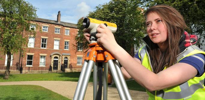
4. Group work. Look at the picture and think what you can speculate about the human activity depicted in the picture. Individually write down everything that you associate with this human activity. Then, share your ideas with your group.
The following questions can be helpful: 1. What sphere of human activity is depicted in the picture? 2. When and where did it emerge? What were the first results of this activity? 3. What does this profession deal with and what do these professionals do? How does this activity influence people’s life? 5. Group work. Report your ideas to the class in order to put them on the board. 6. Structure the received information in the form of the “ cluster ” (графическая организация материала, показывающая смысловые поля того или иного понятия):
Speaking & Listening 7. Group work. Prepare a presentation about cadastral activities and deliver the presentation to the class. Get ready to discuss different points of view answering questions and persisting in your own opinion.
|
|||||||||||||||||||||||||||||||||||||||||||||||||||||||||||||||||||||||||||||||||||||||||||||||||||||||||||||||||||||||||||||||||||||||||||||||||||||||||||||||||||||||||||||||||||||||||||||||||||||||||||||||||||||||||||
|
|
Последнее изменение этой страницы: 2021-03-09; просмотров: 364; Нарушение авторского права страницы; Мы поможем в написании вашей работы! infopedia.su Все материалы представленные на сайте исключительно с целью ознакомления читателями и не преследуют коммерческих целей или нарушение авторских прав. Обратная связь - 3.15.10.137 (0.014 с.) |