Заглавная страница Избранные статьи Случайная статья Познавательные статьи Новые добавления Обратная связь FAQ Написать работу КАТЕГОРИИ: ТОП 10 на сайте Приготовление дезинфицирующих растворов различной концентрацииТехника нижней прямой подачи мяча. Франко-прусская война (причины и последствия) Организация работы процедурного кабинета Смысловое и механическое запоминание, их место и роль в усвоении знаний Коммуникативные барьеры и пути их преодоления Обработка изделий медицинского назначения многократного применения Образцы текста публицистического стиля Четыре типа изменения баланса Задачи с ответами для Всероссийской олимпиады по праву 
Мы поможем в написании ваших работ! ЗНАЕТЕ ЛИ ВЫ?
Влияние общества на человека
Приготовление дезинфицирующих растворов различной концентрации Практические работы по географии для 6 класса Организация работы процедурного кабинета Изменения в неживой природе осенью Уборка процедурного кабинета Сольфеджио. Все правила по сольфеджио Балочные системы. Определение реакций опор и моментов защемления |
Geographical position of the USAСодержание книги
Поиск на нашем сайте
MODULE 2. MODERN REALIA OF THE UNITED STATES OF AMERICA (USA) GEOGRAPHY OF THE USA
The term “United States”, when used in the geographical sense, means the 48 states of continental United States, Alaska, Hawaii, Puerto Rico, Guam, and the Virgin Islands of the United States. Forty-eight of the States are in the single region between Canada and Mexico; this group is referred to, with varying precision and formality, as the continental or contiguous United States, and as the Lower 48. Alaska, which is not included in the term contiguous United States, is at the northwestern end of North America, separated from the Lower 48 by Canada. The State of Hawaii is an archipelago in the Pacific Ocean. Geographical position of the USA The United States of America is a country in the Western Hemisphere. The United States shares land borders with Canada (to the north) and Mexico (to the south), and a territorial water border with Russia in the northwest. The contiguous forty-eight states are otherwise bounded by the Pacific Ocean on the west, the Atlantic Ocean on the east, and the Gulf of Mexico to the southeast. Alaska borders the Pacific Ocean to the south, the Bering Strait to the west, and the Arctic Ocean to the north, while Hawaii lies far to the southwest of the mainland in the Pacific Ocean. The capital city, Washington, District of Columbia, is a federal district located on land donated by the state of Maryland. (Virginia had also donated land, but it was returned in 1847). Total U.S. area is 9,631,418 km², of which land is 9,161,923 km² and water is 469,495 km². Ranked by land area, the top countries in order are Russia, China, the U.S., and Canada. State symbols of the USA The flag of the USA
The US Great Seal The image from the obverse (front) of the Great Seal is often used informally as national arms of the USA. It is only attached (affixed) to certain documents, such as foreign treaties and presidential proclamations. Both sides of the Great Seal can be seen on the back of a U.S. one-dollar bill.
The shield the eagle bears on its breast, though sometimes drawn incorrectly, has two main differences from the American flag. First, it has no stars on the blue chief (though other arms based on it do: the chief of the arms of the United States Senate may show 13 or 50, and the shield of the 9/11 Commission has, sometimes, 50 mullets on the chief). Second, unlike the American flag, the outermost stripes are white, not red; so as not to violate the heraldic rule of tincture.
The USA bird symbol
The USA national anthem “The Star-Spangled Banner” is the national anthem of the United States of America. The lyrics come from a poem written in 1814 by Francis Scott Key, a then 35-year-old amateur poet. The poem was set to the tune of a popular British drinking song “To Anacrean in Heaven”, written by John Stafford Smithfor the Anacreontic Society, a London social club. Although the song has 4 stanzas, onle the first is commonly sung today: O! say can you see by the dawn’s early light What so proudly we hailed at the twilight’s last gleaming. Whose broad stripes and bright stars through the perilous fight, O’er the ramparts we watched were so gallantly streaming. And the rockets’ red glare, the bombs bursting in air, Gave proof through the night that our flag was still there. OHH, say does that star-spangled banner yet wave O’er the land of the free and the home of the brave? The USA physical geography The contiguous United States may be divided into seven broad physiographic divisions: from east to west, the Atlantic–Gulf Coastal Plain; the Appalachian Highlands; the Interior Plains; the Interior Highlands; the Rocky Mountain System; the Intermontane Region; and the Pacific Mountain System. An eighth division, the Laurentian Uplands, a part of the Canadian Shield, dips into the United States from Canada in the Great Lakes region. It is an area of little local relief, with an irregular drainage system and many lakes, as well as some of the oldest exposed rocks in the United States. The Atlantic–Gulf Coastal Plain begins at Cape Cod and Long Island (moraines and outwash plains) and contains southeastern Atlantic and Gulf continental shelf – includes all of Florida and Louisiana. It is low and flat. The Appalachian Highlands sweeping from Newfoundland to Alabama dominate the landscape of the Eastern seaboard. Their peaks, ridges, hills, and valleys form a belt almost 3,200 kilometers long and up to 580 kilometers wide. The Interior Plains may be divided into two sections: the fertile central lowlands, the agricultural heartland of the United States; and the Great Plains, a treeless plateau that gently rises from the central lowlands to the foothills of the Rocky Mountains. The Interior Highlands are located just West of the Mississippi River between the Interior Plains and the Gulf Coastal Plain. This region consists of the rolling Ozark Plateau to the north and the Ouachita Mountains, which are similar in structure to the ridge and valley section of the Appalachians, to the east. The Rocky Mountain System is a geologically young and complex system that extends into northwest United States from Canada and runs south into New Mexico. There are numerous high peaks in the Rockies; the highest is Mountain Elbert (4,399 m). The Rocky Mountains are divided into four sections – the Northern Rockies, the Middle Rockies, the Wyoming (Great Divide) Basin, and the Southern Rockies. Along the crest of the Rockies is the Continental Divide, separating Atlantic-bound drainage from that heading for the Pacific Ocean. The Intermontane Region is between the Rocky Mountains and the ranges to the west. It is an arid expanse of plateaus, basins, and ranges. The Columbia Plateau, in the north of the region, was formed by volcanic lava and is drained by the Columbia River and its tributary the Snake River, both of which have cut deep canyons into the plateau. The enormous Colorado Plateau, an area of sedimentary rock, is drained by the Colorado River and its tributaries; there the Colorado River has entrenched itself to form the Grand Canyon, one of the world’s most impressive scenic wonders. West of the plateaus is the Basin and Range province, an area of extensive semidesert.
the Grand Canyon The Pacific Mountain System is between the Intermontane Region and the Pacific Ocean. It is a series of ranges generally paralleling the coast, formed by faulting and volcanism. The Cascade Range, with its numerous volcanic peaks extends south from southwest Canada into northern California, and from there is continued south by the Sierra Nevada, a great fault block. Mountain Whitney (4,418 m), in the Sierra Nevada, is the highest peak in the contiguous United States. Alaska contains some of the most dramatic and untapped scenery in the country. Tall, prominent mountain ranges rise up sharply from broad, flat tundra plains. On the islands off the south and southwest coast are many volcanoes. Hawaii, far to the south of Alaska in the Pacific Ocean, is a chain of tropical, volcanic islands, popular as a tourist destination for many from East Asia and the mainland United States. The USA major cities The biggest city in the USA is New York City, New York, which has over 8 million people. The second-biggest city in the USA is Los Angeles, California, which has almost 4 million people. Here is the list of some other big cities. Minneapolis, Minnesota Minneapolis, in conjunction with its neighboring city, St Paul, has a population of more than two million. Known as the Twin Cities, Minneapolis and St Paul serve as the financial and cultural center of Minnesota. St. Louis, Missouri Located on the Mississippi River, which separates Missouri from Illinois, St Louis is known as the Gateway to the West. This heritage is symbolized by the city’s famous Gateway Arch, which was built in 1965 and is 192 m high. With a population of approximately 2,6 million, St Louis offers a vibrant waterfront area, a zoo, and art and history museums. Boston, Massachusetts Boston is the capital of Massachusetts and the largest city in New England. Known for its charming neighborhoods and historic landmarks, Boston’s greater metropolitan area is home to more than five million people. Philadelphia, Pennsylvania Founded in 1682, Philadelphia boasts a historic past. This is the city that witnessed the writing of the Declaration of Independence and the signing of the U.S. Constitution. Home to more than five million residents in the metropolitan area, Philadelphia is just two hours from both New York City and Washington, D.C. Atlanta, Georgia Atlanta is the business center of the Southeast, with CNN, Coca-Cola, Delta Airlines, and United Parcel Service all headquartered there. This city of four million also has professional sports, a world-class orchestra, and charming neighborhoods. Dallas, Texas Dallas – along with its neighboring city, Ft Worth – is home to five million residents and has a distinctly western flavor. Culture and international business go hand-in-hand here: the city is famous for its live rodeos and country music and is also home to major corporations. Miami, Florida This city of two million is located on the southernmost tip of Florida and encompasses more than 80 miles of Atlantic coastline. The city is known for its Cuban flavor, beautiful beaches, and plentiful nightlife. Las Vegas, Nevada The “Entertainment Capital of the World” is home to more than 1,5 million people in the metropolitan area. Las Vegas is a culturally and ethnically diverse city with a history steeped in African-American, Hispanic, European, Native American, and Asian heritage. Located in southeastern Nevada, Las Vegas has a dry desert climate. Las Vegas is a popular tourist destination that features resorts and outdoor recreational areas. Phoenix, Arizona Phoenix is the capital of Arizona and is now the sixth-largest city in the United States, with a population of more than three million. Located in the Sonoran desert, Phoenix enjoys a warm, sunny climate all year round. Summers are hot, but in the winter many Americans migrate to the Phoenix area to escape the cold weather, snow, and ice in other parts of the country. This may explain why some of the fastest growing cities in the United States are in Arizona. Seattle, Washington Seattle is located on Puget Sound approximately 100 miles south of the U.S.-Canadian border. The city is home to more than three million people, and is a commercial, cultural, and technological hub of the Pacific Northwest. Surrounded by mountains and water, Seattle features picture-perfect views and abundant recreational opportunities year-round. The USA economic geography The United States has a capitalistmixed economy, which is fueled by abundant natural resources, a well-developed infrastructure, and high productivity. Mining. The United States is a major contributor to the global mining industry – petroleum, natural gas and coal. Agriculture – is a major industry in the United States and the country is a net exporter of food. The country is a top producer of corn, soy beans, rice, and wheat. Beef cattle rank as most valuable product of American farms. Other leading farm products, in order of value, include milk, chickens and eggs, cotton. US farms also produce large amounts of hay, tobacco, turkeys, potatoes, tomatoes, apples and peanuts. Fishing. The greatest quantities of fish are taken from the Gulf of Mexico (shrimp, oysters). The Pacific Ocean supplies Alaska Pollock, cod, crabs, herring, salmon, tuna. The Atlantic yields cod, flounder, herring and other fish. Manufacturing. The value of American manufactured goods is greater than that of any other country. The leading categories of US products are, in order of importance, transportation equipment, food products, chemicals, nonelectrical machinery, electrical machinery and equipment, fabricated metal products, printed materials, primary metals, paper products, scientific and medical instruments. Services: finance, insurance, real estate, commodity and security exchanges. Creative industries: include more than 12,000 stations, about 1,550 television stations, and more than 1,400 cable TV systems. Hollywood film industry and popular music also make a great contribution to the country’s economy. Transport. The backbone of the nation’s transportation infrastructure is a network of high-capacity highways. America created car culture, so don’t be surprised by the fact that nearly everyone of legal driving age has a car and uses it at every possible opportunity. The rail network is among the world’s best, though the passenger rail network is underdeveloped by European and Japanese standards. For a country that owes so much to the penetration of railroads and that has such a potent railroad mythology, the US has a train system that can be surprisingly impractical and not always comfortable. Ticket prices vary in value, but the earlier you make a reservation, the cheaper the ticket. Air travel is the preferred means of travel for long distances. Most visitors arrive by air, and heavy competition on popular routes means that inexpensive flights are often available. The main international airports are in Boston, New York, Washington, Miami, Chicago, Dallas-Fort Worth, Houston, Atlanta, Denver, Seattle, San Francisco and Los Angeles. There are connecting flights from these airports to hundreds of other US cities. IT. The major centres for technology in the USA are the San Francisco Bay and the Pacific Northwest. Silicon Valley is the southern part of the San Francisco Bay Area in Northern California, United States. The term originally referred to the region’s large number of silicon chip innovators and manufacturers, but eventually came to refer to all the high-tech businesses in the area; it is now generally used as ametonym for the high-tech sector. Despite the development of other high-tech economic centers throughout the United States, Silicon Valley continues to be the leading high-tech hub because of its large number of engineers and venture capitalists. Geographically, Silicon Valley encompasses the northern part of Santa Clara Valley and adjacent communities. Glossary
Comprehension Exercise 1. Fill in the gaps in the following text with proper names: The United States of America (also known as the _________, the _______, the _______, and __ ________) is a country in ________ that shares land borders with _______ and _______, and a sea border with __________. Extending from the __________ Ocean to the __________ Ocean, the United States is a federal republic, with its capital in _____________. Exercise 2. Answer the following questions bout the state symbols of the United States: 1. What is the flag of the US called? Describe it and the symbolic meaning of its parts. 2. What fulfills the functions of the coat of arms in the US? Describe it. 3. What is the bird symbol of the country? 4. What is the national anthem of the USA called? Exercise 8. MODULE 2. MODERN REALIA OF THE UNITED STATES OF AMERICA (USA) GEOGRAPHY OF THE USA
The term “United States”, when used in the geographical sense, means the 48 states of continental United States, Alaska, Hawaii, Puerto Rico, Guam, and the Virgin Islands of the United States. Forty-eight of the States are in the single region between Canada and Mexico; this group is referred to, with varying precision and formality, as the continental or contiguous United States, and as the Lower 48. Alaska, which is not included in the term contiguous United States, is at the northwestern end of North America, separated from the Lower 48 by Canada. The State of Hawaii is an archipelago in the Pacific Ocean. Geographical position of the USA The United States of America is a country in the Western Hemisphere. The United States shares land borders with Canada (to the north) and Mexico (to the south), and a territorial water border with Russia in the northwest. The contiguous forty-eight states are otherwise bounded by the Pacific Ocean on the west, the Atlantic Ocean on the east, and the Gulf of Mexico to the southeast. Alaska borders the Pacific Ocean to the south, the Bering Strait to the west, and the Arctic Ocean to the north, while Hawaii lies far to the southwest of the mainland in the Pacific Ocean. The capital city, Washington, District of Columbia, is a federal district located on land donated by the state of Maryland. (Virginia had also donated land, but it was returned in 1847). Total U.S. area is 9,631,418 km², of which land is 9,161,923 km² and water is 469,495 km². Ranked by land area, the top countries in order are Russia, China, the U.S., and Canada. State symbols of the USA The flag of the USA
The US Great Seal The image from the obverse (front) of the Great Seal is often used informally as national arms of the USA. It is only attached (affixed) to certain documents, such as foreign treaties and presidential proclamations. Both sides of the Great Seal can be seen on the back of a U.S. one-dollar bill.
The shield the eagle bears on its breast, though sometimes drawn incorrectly, has two main differences from the American flag. First, it has no stars on the blue chief (though other arms based on it do: the chief of the arms of the United States Senate may show 13 or 50, and the shield of the 9/11 Commission has, sometimes, 50 mullets on the chief). Second, unlike the American flag, the outermost stripes are white, not red; so as not to violate the heraldic rule of tincture.
The USA bird symbol
The USA national anthem “The Star-Spangled Banner” is the national anthem of the United States of America. The lyrics come from a poem written in 1814 by Francis Scott Key, a then 35-year-old amateur poet. The poem was set to the tune of a popular British drinking song “To Anacrean in Heaven”, written by John Stafford Smithfor the Anacreontic Society, a London social club. Although the song has 4 stanzas, onle the first is commonly sung today: O! say can you see by the dawn’s early light What so proudly we hailed at the twilight’s last gleaming. Whose broad stripes and bright stars through the perilous fight, O’er the ramparts we watched were so gallantly streaming. And the rockets’ red glare, the bombs bursting in air, Gave proof through the night that our flag was still there. OHH, say does that star-spangled banner yet wave O’er the land of the free and the home of the brave? The USA physical geography The contiguous United States may be divided into seven broad physiographic divisions: from east to west, the Atlantic–Gulf Coastal Plain; the Appalachian Highlands; the Interior Plains; the Interior Highlands; the Rocky Mountain System; the Intermontane Region; and the Pacific Mountain System. An eighth division, the Laurentian Uplands, a part of the Canadian Shield, dips into the United States from Canada in the Great Lakes region. It is an area of little local relief, with an irregular drainage system and many lakes, as well as some of the oldest exposed rocks in the United States. The Atlantic–Gulf Coastal Plain begins at Cape Cod and Long Island (moraines and outwash plains) and contains southeastern Atlantic and Gulf continental shelf – includes all of Florida and Louisiana. It is low and flat. The Appalachian Highlands sweeping from Newfoundland to Alabama dominate the landscape of the Eastern seaboard. Their peaks, ridges, hills, and valleys form a belt almost 3,200 kilometers long and up to 580 kilometers wide. The Interior Plains may be divided into two sections: the fertile central lowlands, the agricultural heartland of the United States; and the Great Plains, a treeless plateau that gently rises from the central lowlands to the foothills of the Rocky Mountains. The Interior Highlands are located just West of the Mississippi River between the Interior Plains and the Gulf Coastal Plain. This region consists of the rolling Ozark Plateau to the north and the Ouachita Mountains, which are similar in structure to the ridge and valley section of the Appalachians, to the east. The Rocky Mountain System is a geologically young and complex system that extends into northwest United States from Canada and runs south into New Mexico. There are numerous high peaks in the Rockies; the highest is Mountain Elbert (4,399 m). The Rocky Mountains are divided into four sections – the Northern Rockies, the Middle Rockies, the Wyoming (Great Divide) Basin, and the Southern Rockies. Along the crest of the Rockies is the Continental Divide, separating Atlantic-bound drainage from that heading for the Pacific Ocean. The Intermontane Region is between the Rocky Mountains and the ranges to the west. It is an arid expanse of plateaus, basins, and ranges. The Columbia Plateau, in the north of the region, was formed by volcanic lava and is drained by the Columbia River and its tributary the Snake River, both of which have cut deep canyons into the plateau. The enormous Colorado Plateau, an area of sedimentary rock, is drained by the Colorado River and its tributaries; there the Colorado River has entrenched itself to form the Grand Canyon, one of the world’s most impressive scenic wonders. West of the plateaus is the Basin and Range province, an area of extensive semidesert.
the Grand Canyon The Pacific Mountain System is between the Intermontane Region and the Pacific Ocean. It is a series of ranges generally paralleling the coast, formed by faulting and volcanism. The Cascade Range, with its numerous volcanic peaks extends south from southwest Canada into northern California, and from there is continued south by the Sierra Nevada, a great fault block. Mountain Whitney (4,418 m), in the Sierra Nevada, is the highest peak in the contiguous United States. Alaska contains some of the most dramatic and untapped scenery in the country. Tall, prominent mountain ranges rise up sharply from broad, flat tundra plains. On the islands off the south and southwest coast are many volcanoes. Hawaii, far to the south of Alaska in the Pacific Ocean, is a chain of tropical, volcanic islands, popular as a tourist destination for many from East Asia and the mainland United States.
|
||||||||||||||||||||||||||||||
|
|
Последнее изменение этой страницы: 2016-04-08; просмотров: 720; Нарушение авторского права страницы; Мы поможем в написании вашей работы! infopedia.su Все материалы представленные на сайте исключительно с целью ознакомления читателями и не преследуют коммерческих целей или нарушение авторских прав. Обратная связь - 3.140.185.194 (0.007 с.) |

 The flag of the US (also known as Old Glory, Stars and Stripes or Star-Spangled Banner) consists of 13 horizontal stripes, 7 red alternating with 6 white. The stripes represent the original 13 colonies, the stars represent the 50 states of the Union. The colors of the flag are symbolic as well: Red symbolizes Hardiness and Valor, White symbolizes Purity and Innocence and Blue represents Vigilance, Perseverance and Justice.
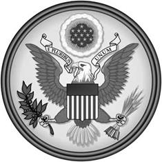 The main figure on the obverse of the seal is a bald eagle with its wings outstretched (or “displayed”, in heraldic terms). From the eagle’s perspective, it holds a bundle of 13 arrows in its left talon, (referring to the 13 original states), and an olive branch, in its right talon, together symbolizing that the United States of America has “a strong desire for peace, but will always be ready for war”. Although not specified by law, the olive branch is usually depicted with 13 leaves and 13 olives, again representing the 13 original states. The eagle has its head turned towards the olive branch, said to symbolize a preference for peace. In its beak, the eagle clutches the motto E pluribus unum (“Out of Many, One”). Over its head there appears a “glory” with 13 mullets (stars) on a blue field. In the current (and several previous) dies of the great seal, the 13 stars above the eagle are arranged in rows of 1-4-3-4-1, forming a six-pointed star.
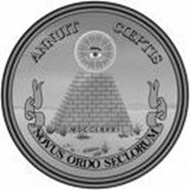 The 1782 resolution adopting the seal blazons the image on the reverse as “A pyramid unfinished. In the zenith an eye in a triangle, surrounded by a glory, proper”. The pyramid is conventionally shown as consisting of 13 layers of blocks to refer to the 13 original states. There are also 13 sides shown on the ribbon. The adopting resolution provides that it is inscribed on its base with the date MDCCLXXVI (1776) in Roman numerals. Where the top of the pyramid should be, the Eye of Providence watches over it. Two mottos appear: Annuit Cœptis signifies that Providence has "approved of (our) undertakings”. Novus Ordo Seclorum, freely taken from Virgil, means “a new order of the ages”.
 The American bald eagle was adopted as the official bird symbol of the United States of America in 1782. The bald eagle was chosen because of it’s majestic beauty, great strength, long life, and because it’s native to North America*.