Заглавная страница Избранные статьи Случайная статья Познавательные статьи Новые добавления Обратная связь КАТЕГОРИИ: ТОП 10 на сайте Приготовление дезинфицирующих растворов различной концентрацииТехника нижней прямой подачи мяча. Франко-прусская война (причины и последствия) Организация работы процедурного кабинета Смысловое и механическое запоминание, их место и роль в усвоении знаний Коммуникативные барьеры и пути их преодоления Обработка изделий медицинского назначения многократного применения Образцы текста публицистического стиля Четыре типа изменения баланса Задачи с ответами для Всероссийской олимпиады по праву 
Мы поможем в написании ваших работ! ЗНАЕТЕ ЛИ ВЫ?
Влияние общества на человека
Приготовление дезинфицирующих растворов различной концентрации Практические работы по географии для 6 класса Организация работы процедурного кабинета Изменения в неживой природе осенью Уборка процедурного кабинета Сольфеджио. Все правила по сольфеджио Балочные системы. Определение реакций опор и моментов защемления |
Main articles: Earth/Geology/Sediments and Sediments
As sediment disperses into the Gulf of Mexico, the water fades to green and then black. Credit: NASA image courtesy the MODIS Rapid Response Team at NASA GSFC. "A burst of color lit the shallow waters of the Gulf of Mexico off the Yucatan Peninsula on December 14, 2008, when the Moderate Resolution Imaging Spectroradiometer (MODIS) on NASA’s Terra satellite captured this image [at right]. The swirls of tan, green, blue, and white are most likely sediment in the water. The sediment scatters light, giving the water its color. The sediment comes from two sources: the land and the sea floor. Some of the color may also come from phytoplankton, tiny plant-like organisms that live in the sun-lit surface waters of the ocean." [10] "Near the shore, the water is tan where rivers carry dirt from land to the ocean. As the sediment disperses, the water fades to green and then black. To the north, the water is more blue and white than tan and green. In these regions, the sediment has likely come from the sea floor. Made up of chalky white calcium carbonate from shell-building marine life like coral, sea floor sediment gives the water a white or bright blue color. The sediment was probably brought to the surface in shallow waters by strong waves. A few days before the image was taken, strong winds churned the Gulf. The blue-green cloud in this image roughly matches the extent of the shallow continental shelf west of the peninsula." [10] Volcanoes[ edit | edit source ] Main article: Volcanoes
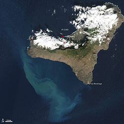
The Advanced Land Imager (ALI) on NASA’s Earth Observing-1 (EO-1) satellite captured this natural-color image of the island and its offshore eruption on December 16, 2011. Credit: esse Allen and Robert Simmon, NASA EO-1 team, and NASA's Earth Observatory. "After two months of eruptions and six months of quakes and tremors, the underwater volcano off the coast of El Hierro appears to be quieting down. A mass of new crust has been building by tens to perhaps a hundred meters, but it is still nowhere near rising above the ocean surface and extending the Canary Island chain." [46] "The Advanced Land Imager (ALI) on NASA’s Earth Observing-1 (EO-1) satellite captured this natural-color image of the island and its offshore eruption on December 16, 2011. The eruption is located about one kilometer south-southwest of the town of La Restinga." [46] "The milky green swirls in the Atlantic Ocean are a volcanic brew of steaming lava fragments, bits of rock, heated gas, and other debris that are carried to the west and north by currents. Meanwhile, tremors have been occurring on the north side of the island at depths of 17 to 23 kilometers. Red circles mark the locations of three tremors reported on December 18. The white puffs over the island are clouds, not volcanic emissions." [46] "El Hierro is a shield volcano growing along the southwestern edge of the ancient El Golfo volcano. El Golfo collapsed about 130,000 years ago, but the ruddy brown and rugged terrain of the island attests to many years of volcanism in the area. El Hierro last erupted in 1793, according to some historical records, and the area has the greatest concentration of young vents in the Canary Islands." [46] Greenstones[ edit | edit source ]
|
||||
|
|
Последнее изменение этой страницы: 2021-05-27; просмотров: 69; Нарушение авторского права страницы; Мы поможем в написании вашей работы! infopedia.su Все материалы представленные на сайте исключительно с целью ознакомления читателями и не преследуют коммерческих целей или нарушение авторских прав. Обратная связь - 18.227.114.125 (0.005 с.) |