Заглавная страница Избранные статьи Случайная статья Познавательные статьи Новые добавления Обратная связь КАТЕГОРИИ: ТОП 10 на сайте Приготовление дезинфицирующих растворов различной концентрацииТехника нижней прямой подачи мяча. Франко-прусская война (причины и последствия) Организация работы процедурного кабинета Смысловое и механическое запоминание, их место и роль в усвоении знаний Коммуникативные барьеры и пути их преодоления Обработка изделий медицинского назначения многократного применения Образцы текста публицистического стиля Четыре типа изменения баланса Задачи с ответами для Всероссийской олимпиады по праву 
Мы поможем в написании ваших работ! ЗНАЕТЕ ЛИ ВЫ?
Влияние общества на человека
Приготовление дезинфицирующих растворов различной концентрации Практические работы по географии для 6 класса Организация работы процедурного кабинета Изменения в неживой природе осенью Уборка процедурного кабинета Сольфеджио. Все правила по сольфеджио Балочные системы. Определение реакций опор и моментов защемления |
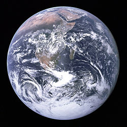
Alternative names: Blue planet, Terra, Planet EarthСтр 1 из 6Следующая ⇒
GEOSCIENCES Матеріали до практичних занять з навчальної дисципліни «Англійська мова (за професійним спрямуванням)»спеціальностей 5.04010301«Пошук та розвідка геологічними методами», 5.04010302 «Пошук та розвідка геофізичними методами», 5.04010302.01 «Геофізичні дослідження у свердловинах», 5.04010302.02 «Комп’ютерна обробка геофізичної інформації», 5.04010303 «Пошук та розвідка гідрогеологічними та інженерно-геологічними методами», 5.04010602 «Прикладна екологія», 5.05030106 «Буріння свердловин». V – VI семестр Lesson 1 Earth science Earth science is an all-embracing term for the sciences related to the planet Earth. Earth science may also be called geoscience. It is a broader term than geology because it includes aspects of planetary science, which is part of astronomy. The Earth sciences include the study of the atmosphere, oceans and biosphere, as well as the solid earth. Typically Earth scientists will use tools from physics, chemistry, biology, chronology and mathematics to understand the Earth, and how it evolved to its current state. If there is one fact which underlies all Earth science it is this: the Earth is an ancient planet which has been changing the whole time since its formation. The extent of the changes is much greater than people used to think. Memorize the words: all-embracing – всеосяжний term – назва, термін broad – широкий to include – містити, включати в себе tool – інструмент, знаряддя to evolve – розвиватися, еволюціонувати ancient – древній, стародавній extent – розмір, ступінь Answer the questions: 1. What does the term “Earth science” mean? What is the synonym for the term? 2. Which term is broader “geoscience” or “geology”? Why? 3. The data from which sciences help us to understand the Earth? 4. Which fact underlies all Earth science? Lesson 2 Geophysics Geophysics ( Some geophysicists now also study the hydrological cycle including snow and ice. They study how the oceans and the atmosphere move. They study electricity and magnetism in the atmosphere, ionosphere, and magnetosphere. How the earth and sun affect each other is also part of geophysics. Geophysics was only recognized as a special area of study in the 19th century. But, there were geophysicists in ancient history. The first magnetic compasses were made in the fourth century BC and the first seismoscope was built in 132 BC. In the 20th century, geophysical methods were developed for remote exploration of the solid Earth and the ocean. Studying geophysics may help with problems such as mineral resources, reducing natural hazards and protecting the environment. Geophysical survey data help find petroleum reservoirs, mineral deposits, and groundwater. Such data can also tell the thickness of glaciers and soils, and tell which areas have environmental damage that should be fixed.
Map of the age of the sea floor made from data about changes in the magnetic field. Memorize the words: environment – оточення, середовище to create – утворювати, створювати to affect – впливати, діяти на… to recognize – упізнавати, визнавати remote – віддалений exploration – дослідження to reduce – зменшувати, знижувати hazard – ризик, загроза survey – огляд, обслідування glacier – льодовик, глетчер soil – ґрунт, земля to fix – лагодити, ремонтувати
Answer the questions: 1. What is the subject of geophysics? 2. What aspects of the geology of the Earth does geophysics study? 3. When were the first magnetic compasses made? 4. When was the first seismoscope built? 5. When was geophysics recognized as a special area of study? 6. What problems can be solved with the help of geophysics? Exercise 1. Translate into English: 1. Можливо, вони вивчають внутрішню структуру Землі. Можливо, зараз вони вивчають магнітне поле Землі. Можливо, ви вже бачили зображення першого сейсмоскопа. Напевне, більшість геофізичних методів було розроблено у 20 столітті. 2. Студентам-геологам слід знати предмет вивчення геофізики. Вам слід було пошукати додаткову інформацію. Студентові не слід було скачувати реферат з Інтернету. 3. Я маю цей текст у комп’ютері, тому не мушу списувати його з дошки. Я повинен вивчити цей уривок напам’ять? – Ні, це не обов’язково, лише вивчи нові слова. Я вивчив текст напам’ять. – Навіщо? Не було потреби тобі це робити. Types of geophysical survey There are many methods and types of instrumentation used in geophysical surveys. Technologies used for geophysical surveys include: 1. Seismic methods, such as reflection seismology, seismic refraction, and seismic tomography. 2. Seism electrical method 3. Geodesy and gravity techniques, including Gravimetry and Gravity gradiometry. 4. Magnetic techniques, including aeromagnetic surveys. 5. Electrical techniques, including electrical resistivity tomography, induced polarization and spontaneous potential. 6. Electromagnetic methods, such as magneto-telluric, ground penetrating radar and transient/time-domain electromagnetics. 7. Borehole geophysics, also called well logging. 8. Remote sensing techniques, including hyper spectral.
Lesson 3 Earth
Physical characteristics
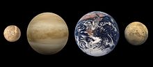
A rough size comparison of Earth and the other three terrestrial planets: Mercury, Venus and Mars. The Earth is the third planet from the Sun. It is one of the four terrestrial planets in our Solar System. This means most of its mass is solid. The other three are Mercury, Venus and Mars. The Earth is home to millions of species of plants and animals, including humans. Earth is the only place in the universe where life has been confirmed to exist. Life is considered an important force in shaping the Earth. (For example, early life forms completely changed its atmosphere). Because of this, life is called a biosphere. About 71% of Earth's surface is covered in salt water oceans. Earth is the only place in the universe where liquid water is known to exist at present.
The other 29% is made of rocky land in the shape of continents and islands. Earth interacts with other objects in the Solar System, particularly the Sun and the Moon. The Earth goes round the Sun roughly once every 365.25 days. One spin of the Earth is called a day and one orbit around the Sun is called a year. This is why there are 365 days in a year. Earth has only one moon, known as the Moon. History The Earth and the other planets formed about 4.6 - 4.8 billion years ago. They were made of the leftover gas from the nebula that made the Sun. The Moon may have been formed after a collision between Earth and a smaller planet (sometimes called Theia). Scientists believe that parts of both planets broke off — becoming (by gravity) the Moon. What it is made of Earth is a terrestrial planet. This means it is made up of solid rock unlike a gas giant such as Jupiter. It is the largest out of the four terrestrial planets in mass and diameter. Chemical composition The Earth is composed mostly of:
Shape The Earth's shape is an oblate spheroid. This means it is basically a sphere but it bulges around the middle. The highest point on Earth is the peak of Mount Everest at 8,848 m above sea level. The lowest natural point is the bottom of the Mariana Trench at 10,911 meters below sea level. Memorize the words: mean -- середній rough – грубий, приблизний terrestrial -- земний species – вид to confirm -- підтверджувати to exist – існувати to consider -- розглядати, вважати to interact – взаємодіяти spin – оберт leftover – залишок nebula – туманність oblate – сплющений біля полюсів to bulge – випинатися, виступати Answer the questions: 1. What is the difference between equatorial and polar radii of the Earth? 2. What are terrestrial planets of the Solar System? 3. What is called biosphere? 4. How much of Earth’s surface is covered by salt water? 5. What is called a year and a day? 6. How old is the Earth? 7. What were the planets of the Solar System made of? 8. Name at least three main chemical elements of which Earth is composed. 9. What is the form of the Earth?
Lesson 4 The layers of the Earth The crust is the outer hard layer of the Earth. The crust is the part of the lithosphere. The crust is made up of different types of rocks: igneous, metamorphic and sedimentary rocks. Below the crust is the mantle. The upper part of the mantle is made up of peridotite, a rock denser than the rocks common in the crust. The crust and the upper mantle make up the lithosphere. The lithosphere is broken up into tectonic plates that can move. The Earth’s crust is less than 1% of Earth’s volume. The crust has two different parts. One is the continental crust (under the land) and the other is oceanic crust (under the ocean). The continental crust is thicker and the oceanic crust is thinner. The thickness of the crust can be anywhere from 5 to 70 km. The temperature of the crust increases with depth. Where the crust meets the mantle the temperatures can be between 200oC and 400oC. About 75% of the Earth’s crust is composed of two elements – oxygen and silicon. These usually occur in combination with common metals such as aluminium and iron. (% by weight: oxygen, silica, aluminium, iron, and all others).
Lesson 5 Plate tectonics
A map showing the Earth's major tectonic plates. Plate tectonics is a theory of geology. It has been developed to explain large scale motions of the Earth's lithosphere. This theory builds on older ideas of continental drift and seafloor spreading. Dissipation of heat from the mantle is the original source of energy driving plate tectonics. Exactly how this works is still a matter of debate. The driving forces of plate motion continue to be active subjects of on-going research. The key principle of plate tectonics is that the lithosphere exists as separate and distinct tectonic plates, which float on the fluid-like (viscous-elastic) solid asthenosphere. The relative fluidity of the asthenosphere allows the tectonic plates to undergo motion in different directions. This map shows 15 of the largest plates. The tectonic plates of the world were mapped in the second half of the 20th century.
Memorize the words: Continental drift – дрейф континентів seafloor spreading – розсування морського дна dissipation – розсіювання driving force – рушійна сила on-going – існуючий, той, що триває distinct – виразний, чіткий fluid-like – рідиноподібний viscous – в’язкий, тягучий to undergo – зазнавати Answer the questions: 1. What is the driving force of plate movements? 2. How does the lithosphere exist? 3. What do the lithosphere plates float on? 4. What allows the tectonic plates to undergo motion? 5. When were the tectonic plates of the world mapped?
Lesson 6
Movement of plates The lithosphere consists of tectonic plates. There are eight major and many minor plates. The lithospheric plates ride on the asthenosphere. These plates move at one of three types of plate boundaries: constructive, destructive and transform.
In other words, when tectonic plates move:
a) together = mountains; volcanoes. For example: the Andes mountain range in South America, the Himalayas, also the Pacific Ring of Fire. b) away = earthquakes, trenches. The Mid-ocean Ridges are examples. c) side to side = earthquakes. The San Andreas Fault in California is an example of a transform boundary. The lateral movement of the plates varies from:
Memorize the words: to ride – їхати верхи divergent – що розходиться convergent – що сходиться transform – видозміна, перетворення rift – розлом, розколина to grind – молоти, розмелювати lateral – горизонтальний, латеральний to vary – мінятися, змінюватися
Answer the questions: 1. What are the three types of boundaries at which tectonic plates move? 2. What is a divergent boundary? 3. What is a convergent boundary? 4. How do plates move at a transform boundary? 5. How quickly do tectonic plates move? Lesson 7 Seafloor spreading Seafloor spreading is a process that occurs at mid-ocean ridges, where new oceanic crust is formed through volcanic activity and then gradually moves away from the ridge. When oceanic plates diverge, fractures occur in the lithosphere. Basaltic magma rises up the fractures and cools on the ocean floor to form new sea floor. Older rocks will be found further away from the spreading zone while younger rocks will be found nearer to the spreading zone.
Age of oceanic crust; youngest (red) is along spreading centres. Mid-ocean ridges A mid-ocean ridge is a general term for an underwater mountain system that consists of various mountain ranges (chains), typically having a valley known as a rift running along its spine, formed by plate tectonics. This type of oceanic ridge is characteristic of what is known as an oceanic spreading centre. The uplifted seafloor results from convection currents which rise in the mantle as magma at a linear weakness (weakened zone) in the oceanic crust, and emerge as lava, creating new crust upon cooling. A mid-ocean ridge demarcates the boundary between two tectonic plates, and consequently is termed a divergent plate boundary. The mid-ocean ridges of the world are connected and form a single global mid-oceanic ridge system that is part of every ocean, making the mid-oceanic ridge system the longest mountain range in the world. The continuous mountain range is 65,000 km (40,400 mi) long (several times longer than the Andes, the longest continental mountain range), and the total length of the oceanic ridge system is 80,000 km (49,700 mi) long. Black Smokers
Oceanic ridge, including a black smoker A black smoker or sea vent is a type of hydrothermal vent found on the seabed, typically in the abyssal zones. They appear as black chimney-like structures that emit a cloud of black material. The black smokers typically emit particles with high levels of sulphur-bearing minerals, or sulphides. Black smokers are formed when superheated water from below Earth's crust comes in contact with cold ocean water; many minerals precipitate, forming a black chimney-like structure around each vent. The metal sulphides that are deposited can become massive sulphide ore deposits in time. Answer the questions: 1. What occurs in the lithosphere when tectonic plates diverge? 2. What forms the new sea-floor along the spreading zones? 3. Where are the youngest and the oldest rocks along the spreading zone? 4. What is a mid-ocean ridge? 5. Why is a mid-ocean ridge termed a divergent plate boundary?
6. What is a black smoker? 7. What do black smokers emit? 8. What is practical significance of black smokers? Mid-Atlantic Ridge The ridge was central in the breakup of the hypothetical Pangaea that began some 180 million years ago.
The Mid-Atlantic Ridge (MAR) is a mid-ocean ridge, a divergent tectonic plate boundary located along the floor of the Atlantic Ocean, and part of the longest mountain range in the world. It separates the Eurasian Plate and North American Plate in the North Atlantic, and the African Plate from the South American Plate in the South Atlantic. Although the Mid-Atlantic Ridge is mostly an underwater feature, portions of it extend above sea level. The average spreading rate for the ridge is about 2.5 cm per year.
sea-floor spreading – розсування морського дна ridge – гребінь гори, гірський кряж, хребет to diverge – розходитися fracture – розлом, тріщина valley – долина rift – розколина spine – гребінь гори linear – лінійний to emerge – з’являтися,виходити to demarcate – розмежовувати, встановлювати кордон consequently – отже, тому, в результаті vent – вихідний отвір seabed – дно моря abyssal – глибинний chimney – димар, комин to emit – випускати, випромінювати sulphur – bearing – що містять сірку to precipitate – випадати в осад breakup – розвал, розпад
9. Which plates of the Earth’s crust does the Mid-Atlantic Ridge separate? Lesson 8 Volcanology Volcanology (also spelled vulcanology) is the study of volcanoes, lava, magma and other related geology. The term volcanology comes from the Latin word Vulcan, the Roman god of fire. Volcanologists look at volcanic eruptions; collect material from the eruptions, such as ash or pumice, rock and lava samples. A volcano is a mountain where lava (hot, liquid rock) comes from a magma chamber under the ground. Most volcanoes have a volcanic crater at the top. When they are active, materials pour out of it. This includes lava, steam, gaseous compounds of sulphur, ash and broken rock pieces. Volcanoes erupt when magma and pressure come together, and the pressure blows off the top of the solid rock, and the magma pours out. Volcanoes are also found on planets other than Earth, like the Olympus Mons on Mars. Types of volcanoes The lava and pyroclastic material that comes out from volcanoes can make many different kinds of land shapes. There are three basic kinds of volcanoes. a) Shield volcano Shield volcanoes are built out of layers of lava from continual eruptions (without explosions). Because the lava is so fluid, it spreads out, often over a wide area. Shield volcanoes do not grow to a great height, and the layers of lava give the volcano gently sloping sides. Shield volcanoes can produce huge areas of basalt, which is usually what lava is when cooled. Even though their sides are not very steep, shield volcanoes can be huge. Mauna Kea in Hawaii is the biggest mountain on Earth. If it is measured from its base on the floor of the sea, Mauna Kea is even taller than Mount Everest, the tallest mountain on land. b) Caldera volcano Lesson 9 Volcanic activity A traditional way to classify or identify volcanoes is by pattern of their eruptions. Those volcanoes which may erupt again at any time are called active. An active volcano is currently erupting, or it has erupted in the last 10,000 years. Those that are now quiet called dormant (inactive). A dormant volcano is "sleeping," but it could awaken in the future. Those volcanoes which have not erupted in historical times are called extinct. An extinct volcano has not erupted in the past 10,000 years.
Edinburgh Castle on the site of an extinct volcano, c. 1581 Memorize the words: bedrock – корінна, підстильна порода conduit – підвідний канал sill – пластова інтрузія to emit – випускати, випромінювати flank – бік, сторона throat – горло lava flow – лавовий потік vent – вхідний (вихідний) отвір to burst – прориватися, вибухати to feed (fed, fed) – забезпечувати, постачати, to identify – ототожнювати(ся) pattern – зразок currently – зараз, у цей час dormant – бездіяльний, що спить extinct – згаслий Answer the questions: 1. By what two main processes are volcanoes formed? 2. When two tectonic plates meet, which of them usually goes under the other? 3. What makes magma within the magma chamber? 4. What are hot spots thought to be? 5. What are the three types of volcanoes according to the pattern of eruption? 6. Which volcanoes are called active? 7. Why do we say that a dormant volcano “is sleeping”? 8. Which volcanoes do we call extinct?
Lesson 10 Seismology Seismology is the study of what is under the surface of the Earth by measuring vibrations on the Earth's surface. A person who does this is called a seismologist. It is part of the science of geophysics, which studies the physics of the processes that formed the Earth and other planets. Seismology is done by seismologists and geophysicists using devices called geophones, hydrophones or seismometers to pick up the vibrations. Seismology can either be passive, just listening to vibrations caused by earthquakes and volcanic activity, or active, using small explosive charges to send vibrations into the ground. Seismic detectors come in two types, one which measures up and down vibrations, and one which measures side to side vibrations. Both types use an arrangement of a magnet and a coil of wire which will convert the vibrations into an electrical signal which can be stored in a computer for analysis. Seismologists can find the location of earthquakes by plotting received vibrations on a map. They can also pick up underground nuclear tests, and this is what many of the seismic recording stations were set up for. They can also examine the crust in a seismic survey to find information about layers of rock, locate oil or gas fields and to get information about the internal structure of volcanoes. Memorize the words: to measure – вимірювати device – пристрій, прилад to pick up – відбирати, добирати explosive – вибуховий charge – заряд coil – котушка wire – дріт, провід to convert – перетворювати to store – накопичувати, зберігати to plot – накреслювати план to receive – одержувати, отримувати nuclear – ядерний to record – записувати, реєструвати to set up – встановлювати, розміщувати survey – огляд, обслідування to locate – визначати місцезнаходження Answer the questions: 1. What devices do seismologists and geophysicists use? What for? 2. What is passive seismology? 3. How does active seismology work? 4. What are the two types of seismic detectors? 5. How do seismic detectors work? 6. What can seismologists do?
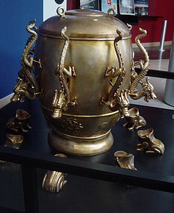
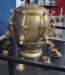
Lesson 11 Earthquakes A replica of (78–139 AD) seismometer. It employed a pendulum sensitive to ground tremors; placed in Luoyang in 133, it detected an earthquake 400 to500 km away in Gansu.
Damage from the San Francisco, California earthquake in 1906. An earthquake (also known as a quake or tremor) is a violent movement of the rocks in the Earth's crust. Earthquakes are usually quite brief, but may repeat over a long period of time. They are the result of a sudden release of energy in the Earth's crust. This creates seismic waves, waves of energy that travel through the Earth. There are large earthquakes and small earthquakes. Big earthquakes can take down buildings and cause death and injury. The study of earthquakes is called seismology. Seismology studies the frequency, type and size of earthquakes over a period of time. When the earth moves offshore in the ocean, it can cause a tsunami. A tsunami can cause just as much death and destruction as an earthquake. Landslides can happen, too. This is an important part of the Earth's cycle. Earthquakes are measured using observations from seismometers. The magnitude of an earthquake, and the intensity of shaking, is measured on a numerical scale. On the scale, 3 or less is scarcely noticeable, and magnitude 7 (or more) causes damage over a wide area. The ancient Chinese also used a device that looked like a jar with dragons on the top surrounded by frogs with their mouths open. When an earthquake occurred, a ball fitted into each dragon's mouth would drop out of the dragon's mouth into the frog's. The position of the frog which received a ball indicated the direction of the earthquake. Memorize the words: earthquake – землетрус replica – точна копія to employ – наймати на роботу, використовувати pendulum – маятник sensitive – чутливий, сприйнятливий tremor, quake – тремтіння, дрижання to detect – виявляти,викривати brief – короткий sudden – раптовий, несподіваний release – вивільнення, звільнення wave – хвиля frequency – частота, частотність offshore – у відкритому морі magnitude – величина, розмір numerical – числовий, цифровий scale – шкала scarcely – ледве noticeable – помітний, гідний уваги jar – глечик to fit in – пристосовувати Answer the questions: 1. What is an earthquake? 2. What is the cause of earthquakes? 3. What creates seismic waves? 4. What does seismology study? 5. What do earthquakes offshore create? 6. How is magnitude of earthquakes measured? 7. How did the seismometer of the ancient Chinese work?
Lesson 12 Earthquake-proofing Some countries, such as Japan or parts of a country like California in the United States, have a lot of earthquakes. In these places it is a good practice to build houses and other buildings which will not collapse during an earthquake. This is called seismic design or "earthquake-proofing".
The Haitian National Palace after at the 2010 Haiti earthquake. Earthquake-proof buildings are constructed to withstand the destructive force of an earthquake. The ability of a building to withstand the stress of an earthquake depends upon its type of construction, shape, mass distribution, and rigidity. Different combinations are used. Square, rectangular, and shell-shaped buildings can withstand earthquakes far better than skyscrapers. To reduce stress, a building's ground floor can be supported by extremely rigid, hollow columns, while the rest of the building is supported by flexible columns located inside the hollow columns. Another method is to use rollers or rubber pads to separate the base columns from the ground, allowing the columns to shake parallel to each other during an earthquake. To help prevent a roof from collapsing, builders make the roof out of light-weight materials. Outdoor walls are made with stronger and more reinforced materials such as steel or reinforced concrete. During an earthquake flexible windows may help hold the windows together so they don’t break. Memorize the words: earthquake-proof – сейсмостійкий, антисейсмічний withstand – протистояти distribution – розподіл rigidity – жорсткість, твердість flexible – гнучкий roller – вал rubber pad – гумова подушка Answer the questions: 1. In which countries are earthquakes frequent? 2. What is called “seismic design”? 3. What does the ability of a building to withstand the stress of an earthquake depend on? 4. Which form of a building is more earthquake-proof? Which is less?
Seismic Methods Seismic method is based on observation of trends of seismic waves and their velocity of propagation. Seismic waves in the rock environment are reflected, refracted or diffracted. The higher velocity of seismic wave propagation is the more solid medium we may expect. Seismic wave propagation velocity can be converted to module of elasticity, or other physical properties of the rock can be derived. Memorize the words: trend – напрям, відхилення velocity – швидкість propagation – поширення solid – тверде тіло medium – середовище convert – перетворювати module – модуль, коефіцієнт elasticity – еластичність, гнучкість derive – виводити, встановлювати походження Answer the questions: 1. What are seismic methods based on? 2. What happens with seismic waves in the rock environment? 3. What does the higher velocity of seismic waves’ propagation mean? 4. What can seismic wave propagation velocity be converted to? Basic principles A simple seismometer that is sensitive to up-down motions of the earth can be understood by visualizing a weight hanging on a spring. The spring and weight are suspended from a frame that moves along with the earth’s surface. As the earth moves, the relative motion between the weight and the earth provides a measure of the vertical ground motion. If a recording system is installed, such as a rotating drum attached to the frame, and a pen attached to the mass, this relative motion between the weight and earth can be recorded to produce a history of ground motion, called a seismogram. Any movement of the ground moves the frame. The mass tends not to move because of its inertia, and by measuring the movement between the frame and the mass, the motion of the ground can be determined.
Memorize the words: sensitive – чутливий, сприйнятливий motion – рух visualize – уявляти, spring – пружина frame – рамка relative – відносний drum – барабан rotate – обертатися attach – прикріпляти
Ancient era
Replica of Zhang Heng's seismoscope Houfeng Didong Yi In AD 132, Zhang Heng of China's Han dynasty invented the first seismoscope (by the definition above), which was called Houfeng Didong Yi (literally, "instrument for measuring the seasonal winds and the movements of the Earth"). The description we have, from the History of the Later Han Dynasty, says that it was a large bronze vessel, about 2 meters in diameter; at eight points around the top were dragon's heads holding bronze balls. When there was an earthquake, one of the mouths would open and drop its ball into a bronze toad at the base, making a sound and supposedly showing the direction of the earthquake. Modern designs The principle can be shown by an early special purpose seismometer. This consisted of a large stationary pendulum, with a stylus on the bottom. As the earth starts to move, the heavy mass of the pendulum has the inertia to stay still in the non-earth frame of reference. The result is that the stylus scratches a pattern corresponding with the Earth's movement. This type of strong motion seismometer recorded upon a smoked glass (glass with carbon soot). While not sensitive enough to detect distant earthquakes, this instrument could indicate the direction of the pressure waves and thus help find the epicenter of a local earthquake – such instruments were useful in the analysis of the 1906 San Francisco earthquake. Memorize the words: pendulum – маятник stylus – грамофонна голка inertia [ɪ'nɜːʃə] – інерція of reference – згаданий scratch – дряпати pattern – малюнок
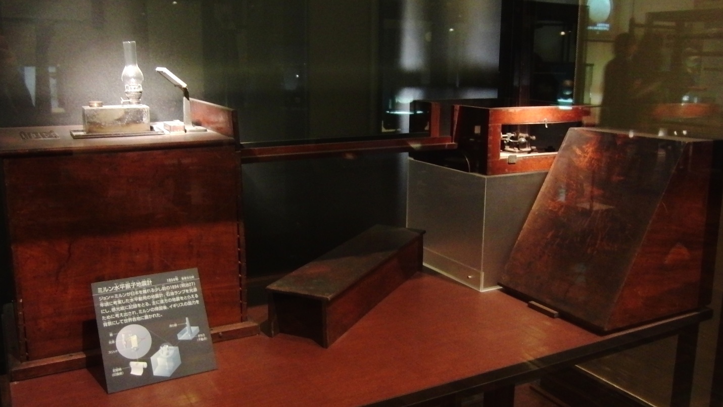
Milne horizontal pendulum seismometer. One of the Important Cultural Properties of Japan. Exhibit in the National Museum of Nature and Science, Tokyo, Japan. · After 1880, most seismometers were descended from those developed by the team of John Milne, James Alfred Ewing and Thomas Gray, who worked in Japan from 1880 to 1895. These seismometers used damped horizontal pendulums. After World War II, these were adapted into the widely used Press-Ewing seismometer. The horizontal pendulum seismograph was improved greatly after World War II. The Press-Ewing seismograph, developed in the United States for recording long-period waves, was widely used throughout the world. This device employed a Milne-type pendulum, but the pivot supporting the pendulum was replaced by an elastic wire to avoid friction. The basic damped horizontal pendulum seismometer swings like the gate of a fence. A heavy weight is mounted on the point of a long (from 10 cm to several meters) triangle, hinged at its vertical edge. As the ground moves, the weight stays unmoving, swinging the "gate" on the hinge. Memorize the words: descend – походити, успадковувати adapt – пристосовувати pivot – стрижень avoid – уникати friction – тертя damped – амортизований swing – гойдатися, коливатися gate – ворота fence – огорожа mount – монтувати, встановлювати point – кінець, вістря triangle – трикутник hinge – завіса, навішувати Magnetometers A magnetometer is a measuring instrument used to measure the strength and, in some cases, the direction of magnetic fields. Magnetometers can be divided into scalar devices which only measure the intensity of the field and vector devices which also measure the direction of the field. Magnetometers are widely used for measuring the Earth's magnetic field and in geophysical surveys to detect magnetic anomalies of various types.
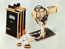
Helium Vector Magnetometer (HVM) of the Pioneer 10 and 11 spacecraft Memorize the words: strength – сила case – випадок direction – напрям scalar – скалярний device – пристрій, винахід vector – вектор(ний) intensity – напруженість, інтенсивність survey – дослідження detect – виявляти, відкривати Answer the questions: 1. What are magnetometers used for? 2. What do scalar magnetometers measure? 3. What can be measured with vector magnetometers? Early magnetometers The first magnetometer was invented by Carl Friedrich Gauss in 1833 and notable developments in the 19th century included the Hall Effect which is still widely used. In 1833, Carl Friedrich Gauss, head of the Geomagnetic Observatory in Gottingen, published a paper on measurement of the Earth's magnetic field. It described a new instrument that consisted of a permanent bar magnet suspended horizontally from a gold fibre. The difference in the oscillations when the bar was magnetised and when it was demagnetised allowed Gauss to calculate an absolute value for the strength of the Earth's magnetic field. A magnetometer may also be called a gaussmeter. The gauss, the CGS unit of magnetic flux density was named in his honour, defined as one maxwell per square centimetre; it equals 1×10⁻⁴ teslas (the SI unit).
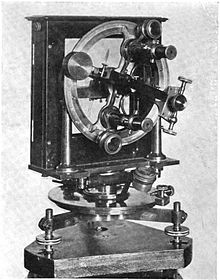
Coast and Geodetic Survey Magnetometer No. 18, used in the magnetic survey of Maryland conducted in the 1890s Memorize the words: Hall effect – ефект Холла – The production of a potential difference across an electrical conductor when a magnetic field is applied in a direction perpendicular to that of the flow of current. Named after Edwin H. Hall (1855 - 1938), American physicist. notable – видатний, значний development – поліпшення, вдосконалення permanent – постійний bar – стрижень suspend – підвішувати fibre – нитка oscillation – коливання value – цінність, значення CGS – від centimetre-gram-second система СГС, сантиметр-грам-секунда unit – одиниця flux – потік maxwell – максвел (одиниця вимірювання магнітного потоку) tesla – тесла (одиниця вимірювання магнітної індукції) SI – the international system of units of measurement Міжнародна система одиниць, СІ equal – дорівнювати Answer the questions: 1. Who and when invented the first magnetometer? 2. What was Carl Friedrich Gauss? 3. What did Gauss’ instrument consist of? 4. What allowed Gauss to calculate an absolute value for the strength of the Earth's magnetic field? 5. What is gauss?
Gauss Karl Friedrich (1777 - 1855), German mathematician, astronomer, and physicist. He laid the foundations of number theory. Faraday Michael (1791 - 1867), English physicist and chemist. He contributed significantly to the study of electromagnetism and discovered the laws of electrolysis. Kelvin William Thomson, 1st Baron (1824 - 1907), British physicist and natural philosopher. He introduced the absolute scale of temperature and restated the second law of thermodynamics. He was involved in the laying of the first Atlantic cable, for which he invented several instruments. Maxwell James Clerk (1831 - 79), Scottish physicist. He extended the ideas of Faraday and Kelvin with his equations of electromagnetism, and he succeeded in unifying electricity and magnetism, identifying the electromagnetic nature of light and postulating the existence of other electromagnetic radiation. Gravimeter
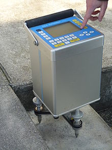
An Autograv CG-5 gravimeter being operated A gravimeter is an instrument used in Gravimetry for measuring the local gravitational field of the Earth. A gravimeter is a type of accelerometer, specialized for measuring the constant downward acceleration of gravity, which varies by about 0.5% over the surface of the Earth. Though the essential principle of design is the same as in other accelerometers, gravimeters are typically designed to be much more sensitive in order to measure very tiny fractional changes within the Earth's gravity of 1 g, caused by nearby geologic structures or the shape of the Earth. Gravimeters display their measurements in units of gals (cm/s2), instead of more common units of acceleration. Gravimeters are used for petroleum and mineral prospecting, seismology, geodesy, geophysical surveys and other geophysical research, and for metrology. There are two types of gravimeters: relative and absolute. Absolute gravimeters measure the local gravity in absolute units, gals. Relative gravimeters compare the value of gravity at one point with another. They must be calibrated at a location where the gravity is known accurately, and then transported to the location where the gravity is to be measured. They measure the ratio of the gravity at the two points. Memorize the words: vary – мінятися, змінюватися though – однак, проте essential – істотний design – конструкція, проектувати sensitive – чутливий tiny – крихітний fractional – дробовий, частковий relative – відносний, порівняльний compare – порівнювати value – значення, величина calibrate – калібрувати, градуювати accurately – точно location – місце ratio – пропорція, співвідношення Answer the questions: What is a gravimeter? Absolute gravimeters Absolute gravimeters, which nowadays are made compact so they can be used in the field, work by directly measuring the acceleration of a mass during free fall in a vacuum, when the accelerometer is rigidly attached to the ground. The mass includes a retroreflector and terminates one arm of a Michelson interferometer. By counting and timing the interference fringes, the acceleration of the mass can be measured. A more recent development is a "rise and fall" version that tosses the mass upward and measures both upward and downward motion. This allows cancellation of some measurement errors; however "rise and fall" gravimeters are not in common use. Absolute gravimeters are used in the calibration of relative gravimeters, surveying for gravity anomalies (voids). Memorize the words: rigidly – жорстко attach – прикріпляти retro - – зворотної дії reflector – рефлектор, відбивач terminate – завершувати time – встановлювати тривалість, визначати час interference fringe – інтерференційна смужка toss – підкидати cancel – скасовувати void – порожнина Answer the questions: 1. What does the mass used in absolute gravimeters include? 2. How is the acceleration of the mass measured? 3. How does the "rise and fall" version of gravimeter work? 4. What are absolute gravimeters used for? Relative gravimeters Most common relative gravimeters are spring-based. They are used in gravity surveys over large areas for establishing the figure of the geoid over those areas. A spring-based relative gravimeter is basically a weight on a spring, and by measuring the amount by which the weight stretches the spring, local gravity can be measured. However, the strength of the spring must be calibrated by placing the instrument in a location with a known gravitational acceleration. The most accurate relative gravimeters are superconducting gravimeters, which operate by suspending a liquid helium cooled diamagnetic superconducting niobium sphere in an extremely stable magnetic field; the current required to generate the magnetic field that suspends the niobium sphere is proportional to the strength of the Earth's gravitational field. The superconducting gravimeter achieves sensitivities of one nanogal, one thousandth of one billionth (10−12) of the Earth surface gravity. In a demonstration of the sensitivity of the superconducting gravimeter, Virtanen (2006) describes how an instrument at Metsähovi, Finland, detected the gradual increase in surface gravity as workmen cleared snow from its laboratory roof. Memorize the words: spring – пружина establish – встановлювати conduct – проводити suspend – підвішувати liquid – рідина, рідкий diamagnetic – діамагнітний niobium – ніобій sphere – сфера, куля stable – стійкий current – струм require – вимагати, потребувати achieve – досягати gradual – поступовий roof – дах Answer the questions: 1. What are relative gravimeters used for? 2. What is basically a relative gravimeter? 3. How can local gravity be measured? 4. What is the design of the most accurate superconducting gravimeters? 5. How was the sensitivity of a superconducting gravimeter demonstrated?
GEOSCIENCES Матеріали до практичних занять з навчальної дисципліни «Англійська мова (за професійним спрямуванням)»спеціальностей 5.04010301«Пошук та розвідка геологічними методами», 5.04010302 «Пошук та розвідка геофізичними методами», 5.04010302.01 «Геофізичні дослідження у свердловинах», 5.04010302.02 «Комп’ютерна обробка геофізичної інформації», 5.04010303 «Пошук та розвідка гідрогеологічними та інженерно-геологічними методами», 5.04010602 «Прикладна екологія», 5.05030106 «Буріння свердловин». V – VI семестр Lesson 1 Earth science Earth science is an all-embracing term for the sciences related to the planet Earth. Earth science may also be called geoscience. It is a broader term than geology because it includes aspects of planetary science, which is part of astronomy. The Earth sciences include the study of the atmosphere, oceans and biosphere, as well as the solid earth. Typically Earth scientists will use tools from physics, chemistry, biology, chronology and mathematics to understand the Earth, and how it evolved to its current state. If there is one fact which underlies all Earth science it is this: the Earth is an ancient planet which has been changing the whole time since its formation. The extent of the changes is much greater than people used to think. Memorize the words: all-embracing – всеосяжний term – назва, термін broad – широкий to include – містити, включати в себе tool – інструмент, знаряддя to evolve – розвиватися, еволюціонувати ancient – древній, стародавній extent – розмір, ступінь Answer the questions: 1. What does the term “Earth science” mean? What is the synonym for the term? 2. Which term is broader “geoscience” or “geology”? Why? 3. The data from which sciences help us to understand the Earth? 4. Which fact underlies all Earth science? Lesson 2 Geophysics Geophysics ( Some geophysicists now also study the hydrological cycle including snow and ice. They study how the oceans and the atmosphere move. They study electricity and magnetism in the atmosphere, ionosphere, and magnetosphere. How the earth and sun affect each other is also part of geophysics. Geophysics was only recognized as a special area of study in the 19th century. But, there were geophysicists in ancient history. The first magnetic compasses were made in the fourth century BC and the first seismoscope was built in 132 BC. In the 20th century, geophysical methods were developed for remote exploration of the solid Earth and the ocean. Studying geophysics may help with problems such as mineral resources, reducing natural hazards and protecting the environment. Geophysical survey data help find petroleum reservoirs, mineral deposits, and groundwater. Such data can also tell the thickness of glaciers and soils, and tell which areas have environmental damage that should be fixed.
Map of the age of the sea floor made from data about changes in the magnetic field. Memorize the words: environment – оточення, середовище to create – утворювати, створювати to affect – впливати, діяти на… to recognize – упізнавати, визнавати remote – віддалений exploration – дослідження to reduce – зменшувати, знижувати hazard – ризик, загроза survey – огляд, обслідування glacier – льодовик, глетчер soil – ґрунт, земля to fix – лагодити, ремонтувати Answer the questions: 1. What is the subject of geophysics? 2. What aspects of the geology of the Earth does geophysics study? 3. When were the first magnetic compasses made? 4. When was the first seismoscope built? 5. When was geophysics recognized as a special area of study? 6. What problems can be solved with the help of geophysics? Exercise 1. Translate into English: 1. Можливо, вони вивчають внутрішню структуру Землі. Можливо, зараз вони вивчають магнітне поле Землі. Можливо, ви вже бачили зображення першого сейсмоскопа. Напевне, більшість геофізичних методів було розроблено у 20 столітті. 2. Студентам-геологам слід знати предмет вивчення геофізики. Вам слід було пошукати додаткову інформацію. Студентові не слід було скачувати реферат з Інтернету. 3. Я маю цей текст у комп’ютері, тому не мушу списувати його з дошки. Я повинен вивчити цей уривок напам’ять? – Ні, це не обов’язково, лише вивчи нові слова. Я вивчив текст напам’ять. – Навіщо? Не було потреби тобі це робити. Types of geophysical survey There are many methods and types of instrumentation used in geophysical surveys. Technologies used for geophysical surveys include: 1. Seismic methods, such as reflection seismology, seismic refraction, and seismic tomography. 2. Seism electrical method 3. Geodesy and gravity techniques, including Gravimetry and Gravity gradiometry. 4. Magnetic techniques, including aeromagnetic surveys. 5. Electrical techniques, including electrical resistivity tomography, induced polarization and spontaneous potential. 6. Electromagnetic methods, such as magneto-telluric, ground penetrating radar and transient/time-domain electromagnetics. 7. Borehole geophysics, also called well logging. 8. Remote sensing techniques, including hyper spectral.
|
|||||||||||||||||||||||||||||||||||||||||
|
|
Последнее изменение этой страницы: 2016-08-06; просмотров: 196; Нарушение авторского права страницы; Мы поможем в написании вашей работы! infopedia.su Все материалы представленные на сайте исключительно с целью ознакомления читателями и не преследуют коммерческих целей или нарушение авторских прав. Обратная связь - 3.135.191.134 (0.414 с.) |
 dʒiːoʊfɪzɪks) is the physics of the Earth and its environment in space. Sometimes geophysics means only studying the geology of the earth such as its shape, gravitational and magneti c field, internal structure and composition. It can also mean how those create plate tectonics, magmas, volcanism and rock formation.


 Memorize the words: