Заглавная страница Избранные статьи Случайная статья Познавательные статьи Новые добавления Обратная связь КАТЕГОРИИ: ТОП 10 на сайте Приготовление дезинфицирующих растворов различной концентрацииТехника нижней прямой подачи мяча. Франко-прусская война (причины и последствия) Организация работы процедурного кабинета Смысловое и механическое запоминание, их место и роль в усвоении знаний Коммуникативные барьеры и пути их преодоления Обработка изделий медицинского назначения многократного применения Образцы текста публицистического стиля Четыре типа изменения баланса Задачи с ответами для Всероссийской олимпиады по праву 
Мы поможем в написании ваших работ! ЗНАЕТЕ ЛИ ВЫ?
Влияние общества на человека
Приготовление дезинфицирующих растворов различной концентрации Практические работы по географии для 6 класса Организация работы процедурного кабинета Изменения в неживой природе осенью Уборка процедурного кабинета Сольфеджио. Все правила по сольфеджио Балочные системы. Определение реакций опор и моментов защемления |
Geography of Continents and Oceans.Стр 1 из 3Следующая ⇒
Geography of Continents and Oceans. Introduction. Geography of the continents and the oceans studies continents, oceans, their geographical position, relief, climatic belts, natural zones, natural resources, peculiarities of vegetable and animal life, population, political map, inland waters. The greater part of the Earth’s surface is occupied by oceans, the smaller – by land. The total surface area of the Earth is 510 million sq km. The area of the land is 149 million sq km, which is only 29% (per cent) of the surface of the globe. The oceans are linked and are really but one great ocean is called the World Ocean. There are five oceans on the globe: the Pacific Ocean, the Atlantic Ocean, the Indian Ocean, the Arctic Ocean and the Southern Ocean. Large landmasses, surrounded by oceans and seas are called mainland or continents. There are 6 continents:
The largest continent is Eurasia. The largest ocean is the Pacific Ocean. The warmest ocean is the Indian Ocean. The smallest and the coldest ocean is the Arctic Ocean. We broadened our knowledge about the life in the World Ocean. While we are studding separate continents and oceans we knew when and by whom they were discovered, who explored them, what people live there, what states are situated on them now. We need deep geographical knowledge in order to stop the pollution of nature. Thanks to this knowledge we understand that we are responsible for our planet on which we live.
Maps Maps are the important source of geographical knowledge. Using maps you may determine the disposition of the continents, oceans, rivers, states. All geographical maps are divided into 3 groups: a) by scale; b) by scope of the territory; c) by content
Geographical Maps Are divided:
by scope of the territory by scale
maps of the world and hemispheres
large scale maps maps of the separate continents
medium scale maps maps of the parts of the continent
small scale maps topographical maps
by content
all geographical maps
special maps
complex maps
The Birth of Maps. The first primitive drawings looking like maps appeared long before people learned to write. Archeologists still find them on the walls of the caves, mammoth tusks and wooden tables. The most ancient pictures of areas were made 10-15 thousand years ago. Cartography as a science appeared in ancient Greece. In the III century BC a famous mathematician and geographer Eratosthenes counted the length of the circumference of the Globe at the meridian. He made up the map of dry land known in those times and showed meridians and parallels on it. Another mathematician, astronomer and cartographer Claudius Ptolemy, who lived in Alexandria in the II century AD, made a book called “The Guide in Geography”. The book determined the development of cartography until the XV century.
Geographical envelope is the inner envelope of the Earth in which the interaction of the upper parts of the Lithosphere with lower parts of atmosphere, hydrosphere and biosphere takes place. All the parts of Geographical Envelope interact with each other. Lithosphere. Lithosphere is an outer layer of the earth crust 10 or 100 km deep, ¼ of whichforms land and ¾ - form oceanic bottom. It consists of 13 blocks, seven of which are very large (Pacific ocean plate, North American plate, South American plate, African plate, Eurasian plate, Indo-Australian plate, Antarctic plate). These blocks include the earth crust of the continents and oceans. Deep rifts separate the blocks from one another. In the places, where continental blocks come together, there are mountains. The blocks can move 1-6 sm a year. The movement of the blocks is connected with the movement of the mantle of the earth. Between the blocks of lithosphere there are active volcanoes and the earthquakes are frequent. These regions are called seismic belts. There are 3 layers in the Earth Crust:
- - Granitic layer - Basaltic layer
Atmosphere is the upper envelope of our planet. It is the mixture of gasses surround the Earth. The role of atmosphere is enormous.
Relief of the Earth. Large territories of the dry land and oceanic cavities, vast plains and mountain ranges form an unusual surface of the Earth. Roughness of the Earth’s surface, which differs in size, origin and age is called therelief. The largest forms of the relief on the Earth are continents and oceanic bottom. We distinguish two forms of relief on the continents: plains and mountains, and on the oceanic bottom – plains, mountains and oceanic cavities. The disposition of them depends on the peculiarities of the Earth Crust. The Earth Crust consists of three layers (sedimentary, granitic and basaltic) on the continent and two layers (sedimentary and basaltic) on the oceanic bottom.
The Earth Crust consists of stable and unstable plots. The formation of the earth crust depends on outer and internal processes. Outer processes are: wind, waters, the sun, ice. Internal processes are: volcanoes, quakes. Climate. One of the main components of nature is climate. Climateis the total sum ofweather during the period of years. The elements of climate are: temperature, rainfalls, atmospheric pressure and winds. There are four reasons, which influence climate: 1. geographical position; 2. relief; 3. oceanic currents; 4. circulation of atmosphere. All the elements of climate are different in different parts of the globe. It depends on the belts of atmospheric pressure. There are three belts of low pressure and four belts of high pressure. The belts of atmospheric pressure form as the result of the distribution of sun warmth on the surface of the Earth and the influence of the rotation of the sun round its axis.
Air Masses.
Air massesare large scope of air of troposphere with the same qualities. There are four types of air masses on the Earth: 1. equatorial; 2. tropical; 3. temperate; 4. arctic and antarctic. While moving the air masses conserve their qualities and determine the weather of the places they come to. The predominant winds depend on the disposition of the belts of the atmospheric pressure. There are trade winds and west winds. They are constant. Monsoons are the winds of season character. The belts of pressure and air masses can move. The system of large air currents of the Earth we call circulation of atmosphere.
Climatic Belts. There are 13 climatic belts. They have different temperature conditions and air masses. Climatic belts are divided into main and transitional.
- Equatorial climatic belt. In equatorial climatic belt all year round predominant equatorial air masses. Atmospheric pressure is low, temperature is high, the sum of rainfalls is large. There is 1 season. - Tropical climatic belt. In tropical climatic belt predominant tropical air masses, high atmospheric pressure, temperature is high. Summer is cooler. It’s seldom rain. There are 2 seasons. - Temperate climatic belt. In temperate climatic belt predominant temperate air masses, west winds. The sum of rainfalls is different in different places. There are 4 seasons. - Arctic and Antarctic climatic belts. They are the coldest climatic belts. Climate here is severe. Atmospheric pressure is high, predominant arctic and antarctic air masses. The transitional climatic belts are situated between the main climatic belts. Natural Complexes. Natural complexis a plot of the surface of the Earth, which differs with peculiaritiesof natural components. All the natural components are connected with each other. If we change one of them, the other changes too. The difference of natural complexes depends on mountain systems, relief and climate. Natural complex can be large or small. Continents are the largest natural complexes on the dry land. Natural complexes form in the oceans too. They consist of the following components: water with soluble gases, plants, animals, rocks and the relief of the bottom. The world ocean is a huge natural complex. We can also find other natural complexes: oceans, seas, bays, straits, rivers, lakes and so on. There are many natural complexes both in the oceans and on the dry land. Natural complexes on the dry land and in the oceans change in different directions: from the north to the south, from the coastlines far into the land, from the foot of the mountain to its top. It depends on climate, the structure of the earth crust, peculiarities of water masses and other reasons, which influence on the formation of natural complexes. Natural zoneis a large natural complex, which has common temperatureconditions, moisture, soils, vegetation and animal world. Natural zones are on the dry land and in the oceans too.
High Altitude Zone. The Andes. We can see the changing of natural zones not only on the continents and oceans, but in the mountains as well. Temperature, pressure and rainfalls change on the height over the sea level. We can find different natural belts in the mountains. In the mountains the natural zones change one goes up the slopes. At the foot of the mountains there is a natural zone peculiar for the surrounding plain. For example, near the equator there are equatorial forests, till altitude 1.200-1.500 m above sea level. Then come the mountain forests. The temperature here is + 12,+20C, rainfalls- 3.000 mm.Treefern, bamboo, cinchonatree grow here. At the height of 2.800- 3.800 m there are alpine forests. Alpine meadows re situated at the height of 4.500 m. Perennial snow and glaciers are at the height of 4.500m and more. The animal life is not rich here. We can see vicuna, chinchilla, condor.
2.The World Ocean. All the planets of the Solar System but the Earth have no oceans. Water occupies ¾ of the surface of the globe, so the continents look like big islands in the World Ocean. The role of the ocean in the life of people increases. It becomes the source of minerals, water, food, energy. Oceanic water is very salty. The salts come into the ocean with the river waters mainly. Oceanic water contains salts, gasses and insoluble particles. Saltiness of water depends on rainfalls and evaporation. In the World Ocean there are four types of water masses: · equatorial; · tropical; · temperate; · polar (arctic and antarctic). There is an interaction between water masses and atmosphere. They exchange warmth, moisture and gasses. Movement of the water masses in the World Ocean takes place on the surface and near the bottom. There are some reasons influencing the formation of water masses: 1. the warmth of the Sun; 2. winds; 3. different to; 4. different saltiness.
The direction of the oceanic currents depend on: · the direction of the winds; · rotation of the Earth; · relief of the bottom; · coastlines of the continents.
The oceanic currents may be: ü permanent; ü periodic; ü wind currents; ü flow currents; ü surface; ü deep; ü near the bottom.
There are warm currents and cold currents.
The World Ocean is very rich. People go fishing. They gather seaweeds for food and corals for jewelry. They also use minerals
There are many different living organisms in the World Ocean. They live on the surface, deep in water and on the bottom. Most of them live in the surface layer, which is 160 meters deep, because the sunbeams warm and lighten the water there. Many animals live not far from the coastlines of the continents and islands. Plankton lives on the surface and is carried by currents. There are also many active living organisms as fish, dolphins, whales, seals, sharks, turtles and so on. Different corals, worms, mollusks live on the bottom.
Ecological Problems of the World Ocean. Pollution. The World Ocean is under threat, because it is polluted a lot. People get oil and some of it usually goes into water. There have recently been several catastrophes, when a lot of oil spread all over some seas and oceanic coastlines. Plants and factories drop poisonous chemicals, litter and waste into the water and make it impossible to live in. Because of such events many birds and animals die, a lot of plankton disappears. It also brings less oxygen to water and all animals and fishes can die out. Big oceans are poisoned only in some places, but small seas are really in danger.
Fishing is another catastrophe. Scientific and technological progress resulted in using by people many devices. Modern ships have special equipment to catch even the whole school of fish. That is why herring and cod are almost caught out. While catching shellfish people damage the bottom. As a result many animals die. Litter. A lot of litter swims in the waters of the World Ocean. Five from seven kinds of turtles live in the seas. Turtles eat jelly-fishes, which live in warm currents and near the coasts of the continents. Sometimes they eat plastic bags by mistake and die. Many turtles die in the nets for catching fish. As a result, many turtles are in danger.
Vocabulary. Total – общий Hemisphere - полушарие Continent - материк Separate - отдельный Layer - слой Oceanic bottom – океаническое дно Earth Crust – земная кора Volcano - вулкан Earthquake - землетрясение Frequent - частый Seismic belt – сейсмический пояс Occupy – занимать Stretch – протянуться Surface – поверхность Cavity – впадина Roughness – неровность Origin –происхождение Lithosphere Atmosphere Peculiarity – особенность Disposition – расположение Sedimentary – осадочный Climate – климат Temperature Rainfalls – осадки Pressure – давление Influence – влиять Oceanic currents – океанические течения Circulation – циркуляция Distribution – распределение Predominant – преобладающий Trade winds – пассаты Monsoons – муссоны Transitional – переходный Equatorial – экваториальный Tropical – тропический Temperate – умеренный Relief – рельеф Vegetation – растительность Evaporation – испарение Moisture – влага
Task 1. Complete the table.
Task 2. Characterize the oceans:
Task 3. 1. The continent that consists of two parts of the world; 2. The smallest continent of the world; 3. The warmest ocean of the world; 4. Part of the world that is formed by two continents; 5. The coldest ocean in the world. A – Australia; B – the Indian Ocean;
C – Eurasia; D – the Arctic Ocean; E – North America; F – South America; G – America; H – The Pacific Ocean; I – Antarctica. Task 4. Complete the table.
Task 5. 1. The outer layer of the earth crust; 2. Large scope of air with the same qualities; 3. The total sum of weather during the period of years; 4. The roughness of the earth; 5. The plot of the surface of the earth with different natural components. A – natural complex; B – natural zone; C – air masses; D – lithosphere; E – climatic belt; F – climate; G – relief; H – highlands. Task 6. Complete the table.
Task 7. Complete the table.
Task 8. Complete the table.
Task 9. Write down the components of natural complexes of the dry land and oceans. Show the connections between the components. a) _________________________________________
b) _________________________________________
Task 10. Complete the table.
Task 11. Form adjectives: 1. Africa – 2. Australia – 3. Ocean – 4. Antarctica – 5. Europe – 6. Asia – 7. Equator – 8. Climate – 9. Nature – 10. Atmosphere – 11. Continent –
The World Ocean. Task 12. Complete the table.
Task 13. Complete the table.
Task 14. The Indian Ocean. 1. The continent that is not washed by the ocean; 2. The island near which the deepest place of the ocean is situated; 3. A warm current of the ocean; 4. The object which separates the Arabian Peninsula from the continent; 5. The warm and salty sea of the ocean. A – Antarctica; B – the Bay of Bengal; C – Monsoon; D – Persian Bay; E – Java; F – North America; G – Red; H – Gulf Stream. Task 15. The Pacific Ocean. 1. The continent that is not washed by the ocean; 2. The sea of the ocean; 3. We can’t see this climatic belt in the ocean; 4. The gulf of the ocean that has the same name as one of the states in the USA; 5. The cold current of the ocean. A – Australia; B – arctic; C – Peruvian; D - Curocio; E – Africa; F – antarctic; G – California; H – South Trade. Task 16. The Atlantic Ocean. 1. A large peninsula in this ocean; 2. The sea of the ocean; 3. A strong warm current; 4. The river that flows into the ocean; 5. The continent that is not washed by this ocean. A – Marmara; B – Gulf Stream; C – Amazon; D – Zambezi; E – Red; F – Australia; G – Labrador; H – Canarian. Task 17. The Arctic Ocean. 1. A large island in the ocean; 2. The current that warms the water in the ocean; 3. The continent that is washed by this ocean; 4. The straight connecting the Arctic and the Pacific Oceans; 5. We can find this climatic belt in the ocean. A – North Atlantic; B – Australia; C – Bering; D – Guinea; E – Greenland; F – antarctic; G – North America; H – arctic.
Africa. Task 18. Geographical Position. 1. The extreme point in the south of Africa; 2. The isthmus that separates Africa from Asia; 3. The sea in the north of Africa; 4. The straight that separates Africa from Europe; 5. The largest gulf of the continent. A – El-Abyard; B – Guinea; C – Red; D – Somaliland; E – Suez; F – Gibraltar; G – Mediterranean; H – Igolny. Task 19. Relief. 1. The young mountains in Africa; 2. The highest volcano of the continent; 3. The mountains in the south of Africa; 4. The desert on the coasts of the Atlantic Ocean; 5. The highlands in the east of Africa. A – Sahara; B – Abyssinian; C – Atlas; D – Alps; E – Drakensberg; F – East-African; G – Kilimanjaro; H – Namib. Task 20. Inland Waters. 1. The river that flows into the Indian Ocean; 2. The longest river in Africa; 3. The largest lake of the continent; 4. The second largest river in Africa; 5. The deepest lake of the continent. A – Nile; B – Tanganyika; C – Congo; D – Aswan; E – Nyasa; F – Victoria; G – Chad; H – Zambezi. Task 21. Natural Zones. 1. There are a lot of fruit trees in this zone; 2. We can see baobabs and high grass there; 3. Lions and snakes live there; 4. Tough leaved evergreen shrubs grow in this zone; 5. The Atlas Mountains are situated in this zone. A – arctic deserts; B – wet equatorial forests; C – taiga; D – savannahs; E – high altitude zone; F – tropical deserts; G – subtropical forests; H – mixed forests.
Australia. Task 22. Geographical Position. 1. The largest coral reef in the world; 2. The gulf in the south of the continent; 3. The sea in the north-east of Australia; 4. A big island near the northern coasts of Australia; 5. The western extreme point of Australia. A – Carpentaria; B – Great Australian; C – Tasmania; D – New Guinea; E – Coral; F – Great Barrier; G – Byron; H – Steep Point. Task 23. Relief and Inland Waters. 1. The longest river of Australia; 2. A big desert in the western part of the continents; 3. The lake in the centre of the continent; 4. The river that is drying; 5. The mountain range in the east. A – Murray; B – Eyre; C – Great Dividing Range; D – Great Sand; E – Great Victoria; F – Darling; G – Australian Alps; H – Mc Kai. Task 24. Climate and Natural Zones. 1. The largest climatic belt in Australia; 2. The Cape York peninsula is situated in this climatic belt; 3. This natural zone occupies the eastern coast of the continent; 4. Lizards and snakes live in this zone; 5. You can find red ferro-aluminum soils in this zone. A – subtropical; B – savannahs; C – deserts; D – equatorial; E – tropical; F – subequatorial; G – monsoon forests; H – temperate.
Antarctica. Task 25. 1. The sea near Antarctica; 2. The nearest continent; 3. The largest peninsula; 4. The name of the explorer, who reached the South Pole the first; 5. The explorer, who died after reaching the South Pole. A – Weddell; B – Lasarev; C – Amundsen; D – Bellingshausen; E – Australia; F – Scott; G – South America; H – Antarctic.
South America. Task 26. Geographical Position. (A) 1. The ocean that washes South America in the east; 2. The only bay of the continent; 3. The traveler who discovered America; 4. The sea in the north of South America; 5. The extreme point in the south of the continent. A – Froward; B – Pacific; C – Drake; D – Atlantic; E – Magellan; F – La Plata; G – Columbus; H – Caribbean. (B) 1. The extreme northern point; 2. The straight between Tierra del Fuego and South America; 3. The canal that connects the Atlantic and the Pacific Oceans; 4. The extreme western point; 5. The extreme eastern point. A – Panama; B – Parinas; C – Kabu – Branku; D – Caribbean; E – Gallinas; F – Froward; G – Magellan; H – Pacific.
Task 27. Relief. (A) 1. The largest plain in the world; 2. The young mountains of the continent; 3. The vast highlands in the eastern part of the continent; 4. The highest peak of the continent; 5. The volcano near the equator. A – Guiana; B – Chimborazo; C – La Plata; D – Amazon; E – Andes; F – Aconcagua; G – Cotopaxi; H – Brazilian. (B) 1. The lowland in the north of the continent; 2. The highlands in the north of the continent; 3. The lowland in the south of the continent; 4. The highest peak of the Andes; 5. The plain, where the biggest river of the continent flows. A – Orinoco; B – Brazilian; C – Amazon; D – La Plata; E – Guiana; F – Cotopaxi; G – Parana; H – Aconcagua.
Task 28. Climate. 1. The cold current near the western coast of the continent; 2. The climatic belt where it is warm and wet all year round; 3. The climatic belt where cape Froward is situated; 4. The type of climate in the Andes; 5. The climatic belt in the north of the continent. A – equatorial; B – Aconcagua; C – temperate; D – Peruvian; E – subtropical; F – tropical; G – alpine; H – subequatorial. Task 29. Inland Waters. 1. The ocean into which all large rivers of South America flow; 2. The river that flows across the La Plata Lowland; 3. The river that rises in the Guiana Highlands; 4. The deepest lake of South America; 5. The greatest river of the continent; 6. The northern tributary of the Amazon River. A – Atlantic; B – Amazon; C – Pacific; D – Titicaca; E – Parana; F – La Plata; G – Indian; H – Orinoco; I – Maracaibo; J – Riu-Negru. Task 30. Natural Zones. 1. You can find grey and brown soils in this zone; 2. You can see a lot of different beetles and butterflies there; 3. Rodents live in this zone and feather bushes grow there. 4. You can find this zone in the Andes; 5. Armadillo and deer live and bottle trees grow in this zone. A – equatorial forests; B – savannahs; C – high altitude zone; D – deserts; E – tundra; F – steppes; G – tough evergreen forests; H – mixed forests. North America. Task 31. Geographical Position. 1. The straight between North America and Eurasia; 2. The gulf in the north of the continent; 3. The name of a big island archipelago in the north of the continent; 4. The largest island in the world; 5. The largest peninsula of the continent. A – Labrador; B – Bering; C – Panama; D – Florida; E – Hudson; F – Mexico; G - Canadian Arctic; H – Greenland. Task 32. Relief. 1. The young mountains in the east; 2. The lowland in the south of the continent; 3. An old mountain system; 4. The highest peak in the Cordilleras; 5. The plain in the middle of the continent. A – McKinley; B – Orizaba; C – Cordilleras; D – Central Plains; E – Great Plains; F - Mississippi; G – Mexican; H – Appalachian.
Task 33. Climate. 1. The climatic belt which occupies the largest part of the continent; 2. The cold current near the western coasts; 3. The climatic belt where night lasts for 5 months; 4. You can’t find this climatic belt in North America; 5. The climatic belt where the Yucatan peninsula is situated. A – equatorial; B – temperate; C - Subequatorial; D - Subtropical; E – Californian; F – arctic; G – Labrador; H – tropical.
Task 34. Inland Waters. 1. The largest river of the continent; 2. One of the Great American Lakes; 3. The river that connects 5 Great Lakes with the Atlantic Ocean; 4. The river with the largest waterfall; 5. The river that flows into the Arctic Ocean. A – Colorado; B – Mackenzie; C – Missouri; D – Mississippi; E – St. Lawrence; F – Superior; G - Niagara; H – Great Salt.
Task 35. Natural Zones. 1. Only moss and lichen grow in this zone; 2. There are a lot of cactuses and prickly shrubs in this zone; 3. Foxes, mustangs and different rodents live in this zone; 4. You can find grey and brown soils in this zone; 5. Polar foxes, reindeer and polar owls live there. A – high altitude; B – savannahs; C – tundra; D – deserts; E – deciduous forests; F – arctic deserts; G – prairies; H – taiga.
Eurasia. Task 36. Geographical Position. 1. The extreme point in the south of Eurasia; 2. The straight that separates Eurasia from North America; 3. The mountains that separate Europe from Asia; 4. The extreme point in the west; 5. The ocean that washes the northern coastlines of Eurasia. A – Arctic; B – Bering; C – Caucasus; D – Piai; E – Pacific; F –Roca; G – Dezhnev; H – Urals.
Task 37. The “Champions” of the continent. 1. The highest mountain of Eurasia; 2. The largest peninsular of the continent; 3. The deepest lake in the world; 4. The wettest place in Eurasia; 5. The coldest place in Eurasia. A – Elbrus; B – Everest; C – Baikal; D – Arabian; E – Balkan; F – North Pole; G - Brahmaputra basin; H – Oimyakon.
Task 38. Relief. 1. The highest mountain system of the world; 2. The plateau on the Hindustan peninsula; 3. The highest active volcano of the continent; 4. An old mountain range of Eurasia; 5. The highest mountains of Europe. A – Deccan; B – Alps; C – Hekla; D - Pamir; E – Scandinavian; F - Klyuchevskaya; G – Carpathians; H - Himalayas.
Task 39. Climate. 1. The climatic belt that occupies the largest territory in Eurasia; 2. The winds that influence the southern part of Eurasia; 3. The high mountains that block the way to the cold arctic winds; 4. The type of the climate on the Apennine peninsular; 5. The circle that crosses Eurasia in the north. A – arctic; B – Himalayas; C – trade winds; D – alpine; E – antarctic; F – temperate; G – Tien-Shan; H – Mediterranean.
Task 40. Inland Waters. 1. The longest river of Europe; 2. The most beautiful lake in the Alps; 3. The water of this river is yellow; 4. The largest salty lake in the world; 5. The tributary of the Yenisei. A – Danube; B – Baikal; C – Angara; D – Hwang Ho; E – Caspian; F – Volga; G – Yangtze; H - Geneva.
Laboratory work.
Table: The World Ocean.
Geography of Continents and Oceans. Introduction. Geography of the continents and the oceans studies continents, oceans, their geographical position, relief, climatic belts, natural zones, natural resources, peculiarities of vegetable and animal life, population, political map, inland waters. The greater part of the Earth’s surface is occupied by oceans, the smaller – by land. The total surface area of the Earth is 510 million sq km. The area of the land is 149 million sq km, which is only 29% (per cent) of the surface of the globe. The oceans are linked and are really but one great ocean is called the World Ocean. There are five oceans on the globe: the Pacific Ocean, the Atlantic Ocean, the Indian Ocean, the Arctic Ocean and the Southern Ocean. Large landmasses, surrounded by oceans and seas are called mainland or continents. There are 6 continents:
The largest continent is Eurasia. The largest ocean is the Pacific Ocean. The warmest ocean is the Indian Ocean. The smallest and the coldest ocean is the Arctic Ocean. We broadened our knowledge about the life in the World Ocean. While we are studding separate continents and oceans we knew when and by whom they were discovered, who explored them, what people live there, what states are situated on them now. We need deep geographical knowledge in order to stop the pollution of nature. Thanks to this knowledge we understand that we are responsible for our planet on which we live.
Maps Maps are the important source of geographical knowledge. Using maps you may determine the disposition of the continents, oceans, rivers, states. All geographical maps are divided into 3 groups: a) by scale; b) by scope of the territory; c) by content
Geographical Maps Are divided:
by scope of the territory by scale
maps of the world and hemispheres
large scale maps maps of the separate continents
medium scale maps maps of the parts of the continent
small scale maps topographical maps
by content
all geographical maps
special maps
complex maps
The Birth of Maps. The first primitive drawings looking like maps appeared long before people learned to write. Archeologists still find them on the walls of the caves, mammoth tusks and wooden tables. The most ancient pictures of areas were made 10-15 thousand years ago. Cartography as a science appeared in ancient Greece. In the III century BC a famous mathematician and geographer Eratosthenes counted the length of the circumference of the Globe at the meridian. He made up the map of dry land known in those times and showed meridians and parallels on it. Another mathematician, astronomer and cartographer Claudius Ptolemy, who lived in Alexandria in the II century AD, made a book called “The Guide in Geography”. The book determined the development of cartography until the XV century.
Geographical envelope is the inner envelope of the Earth in which the interaction of the upper parts of the Lithosphere with lower parts of atmosphere, hydrosphere and biosphere takes place. All the parts of Geographical Envelope interact with each other. Lithosphere. Lithosphere is an outer layer of the earth crust 10 or 100 km deep, ¼ of whichforms land and ¾ - form oceanic bottom. It consists of 13 blocks, seven of which are very large (Pacific ocean plate, North American plate, South American plate, African plate, Eurasian plate, Indo-Australian plate, Antarctic plate). These blocks include the earth crust of the continents and oceans. Deep rifts separate the blocks from one another. In the places, where continental blocks come together, there are mountains. The blocks can move 1-6 sm a year. The movement of the blocks is connected with the movement of the mantle of the earth. Between the blocks of lithosphere there are active volcanoes and the earthquakes are frequent. These regions are called seismic belts. There are 3 layers in the Earth Crust: - - Granitic layer - Basaltic layer
Atmosphere is the upper envelope of our planet. It is the mixture of gasses surround the Earth. The role of atmosphere is enormous.
Relief of the Earth. Large territories of the dry land and oceanic cavities, vast plains and mountain ranges form an unusual surface of the Earth. Roughness of the Earth’s surface, which differs in size, origin and age is called therelief. The largest forms of the relief on the Earth are continents and oceanic bottom. We distinguish two forms of relief on the continents: plains and mountains, and on the oceanic bottom – plains, mountains and oceanic cavities. The disposition of them depends on the peculiarities of the Earth Crust. The Earth Crust consists of three layers (sedimentary, granitic and basaltic) on the continent and two layers (sedimentary and basaltic) on the oceanic bottom.
The Earth Crust consists of stable and unstable plots. The formation of the earth crust depends on outer and internal processes. Outer processes are: wind, waters, the sun, ice. Internal processes are: volcanoes, quakes. Climate. One of the main components of nature is climate. Climateis the total sum ofweather during the period of years. The elements of climate are: temperature, rainfalls, atmospheric pressure and winds. There are four reasons, which influence climate: 1. geographical position; 2. relief; 3. oceanic currents; 4. circulation of atmosphere. All the elements of climate are different in different parts of the globe. It depends on the belts of atmospheric pressure. There are three belts of low pressure and four belts of high pressure. The belts of atmospheric pressure form as the result of the distribution of sun warmth on the surface of the Earth and the influence of the rotation of the sun round its axis.
Air Masses.
Air massesare large scope of air of troposphere with the same qualities. There are four types of air masses on the Earth: 1. equatorial; 2. tropical; 3. temperate; 4. arctic and antarctic. While moving the air masses conserve their qualities and determine the weather of the places they come to. The predominant winds depend on the disposition of the belts of the atmospheric pressure. There are trade winds and west winds. They are constant. Monsoons are the winds of season character. The belts of pressure and air masses can move. The system of large air currents of the Earth we call circulation of atmosphere.
Climatic Belts. There are 13 climatic belts. They have different temperature conditions and air masses. Climatic belts are divided into main and transitional.
- Equatorial climatic belt. In equatorial climatic belt all year round predominant equatorial air masses. Atmospheric pressure is low, temperature is high, the sum of rainfalls is large. There is 1 season. - Tropical climatic belt. In tropical climatic belt predominant tropical air masses, high atmospheric pressure, temperature is high. Summer is cooler. It’s seldom rain. There are 2 seasons. - Temperate climatic belt. In temperate climatic belt predominant temperate air masses, west winds. The sum of rainfalls is different in different places. There are 4 seasons. - Arctic and Antarctic climatic belts. They are the coldest climatic belts. Climate here is severe. Atmospheric pressure is high, predominant arctic and antarctic air masses. The transitional climatic belts are situated between the main climatic belts. Natural Complexes. Natural complexis a plot of the surface of the Earth, which differs with peculiaritiesof natural components. All the natural components are connected with each other. If we change one of them, the other changes too. The difference of natural complexes depends on mountain systems, relief and climate. Natural complex can be large or small. Continents are the largest natural complexes on the dry land. Natural complexes form in the oceans too. They consist of the following components: water with soluble gases, plants, animals, rocks and the relief of the bottom. The world ocean is a huge natural complex. We can also find other natural complexes: oceans, seas, bays, straits, rivers, lakes and so on. There are many natural complexes both in the oceans and on the dry land. Natural complexes on the dry land and in the oceans change in different directions: from the north to the south, from the coastlines far into the land, from the foot of the mountain to its top. It depends on climate, the structure of the earth crust, peculiarities of water masses and other reasons, which influence on the formation of natural complexes. Natural zoneis a large natural complex, which has common temperatureconditions, moisture, soils, vegetation and animal world. Natural zones are on the dry land and in the oceans too.
High Altitude Zone. The Andes. We can see the changing of natural zones not only on the continents and oceans, but in the mountains as well. Temperature, pressure and rainfalls change on the height over the sea level. We can find different natural belts in the mountains. In the mountains the natural zones change one goes up the slopes. At the foot of the mountains there is a natural zone peculiar for the surrounding plain. For example, near the equator there are equatorial forests, till altitude 1.200-1.500 m above sea level. Then come the mountain forests. The temperature here is + 12,+20C, rainfalls- 3.000 mm.Treefern, bamboo, cinchonatree grow here. At the height of 2.800- 3.800 m there are alpine forests. Alpine meadows re situated at the height of 4.500 m. Perennial snow and glaciers are at the height of 4.500m and more. The animal life is not rich here. We can see vicuna, chinchilla, condor.
2.The World Ocean. All the planets of the Solar System but the Earth have no oceans. Water occupies ¾ of the surface of the globe, so the continents look like big islands in the World Ocean. The role of the ocean in the life of people increases. It becomes the source of minerals, water, food, energy. Oceanic water is very salty. The salts come into the ocean with the river waters mainly. Oceanic water contains salts, gasses and insoluble particles. Saltiness of water depends on rainfalls and evaporation. In the World Ocean there are four types of water masses: · equatorial; · tropical; · temperate; · polar (arctic and antarctic). There is an interaction between water masses and atmosphere. They exchange warmth, moisture and gasses. Movement of the water masses in the World Ocean takes place on the surface and near the bottom. There are some reasons influencing the formation of water masses: 1. the warmth of the Sun; 2. winds; 3. different to; 4. different saltiness.
The direction of the oceanic currents depend on: · the direction of the winds; · rotation of the Earth; · relief of the bottom; · coastlines of the continents.
The oceanic currents may be: ü permanent; ü periodic; ü wind currents; ü flow currents; ü surface; ü deep; ü near the bottom.
There are warm currents and cold currents.
The World Ocean is very rich. People go fishing. They gather seaweeds for food and corals for jewelry. They also use minerals
There are many different living organisms in the World Ocean. They live on the surface, deep in water and on the bottom. Most of them live in the surface layer, which is 160 meters deep, because the sunbeams warm and lighten the water there. Many animals live not far from the coastlines of the continents and islands. Plankton lives on the surface and is carried by currents. There are also many active living organisms as fish, dolphins, whales, seals, sharks, turtles and so on. Different corals, worms, mollusks live on the bottom.
Ecological Problems of the World Ocean. Pollution. The World Ocean is under threat, because it is polluted a lot. People get oil and some of it usually goes into water. There have recently been several catastrophes, when a lot of oil spread all over some seas and oceanic coastlines. Plants and factories drop poisonous chemicals, litter and waste into the water and make it impossible to live in. Because of such events many birds and animals die, a lot of plankton disappears. It also brings less oxygen to water and all animals and fishes can die out. Big oceans are poisoned only in some places, but small seas are really in danger.
Fishing is another catastrophe. Scientific and technological progress resulted in using by people many devices. Modern ships have special equipment to catch even the whole school of fish. That is why herring and cod are almost caught out. While catching shellfish people damage the bottom. As a result many animals die. Litter. A lot of litter swims in the waters of the World Ocean. Five from seven kinds of turtles live in the seas. Turtles eat jelly-fishes, which live in warm currents and near the coasts of the continents. Sometimes they eat plastic bags by mistake and die. Many turtles die in the nets for catching fish. As a result, many turtles are in danger.
Vocabulary. Total – общий Hemisphere - полушарие Continent - материк Separate - отдельный Layer - слой Oceanic bottom – океаническое дно Earth Crust – земная кора Volcano - вулкан Earthquake - землетрясение Frequent - частый Seismic belt – сейсмический пояс Occupy – занимать Stretch – протянуться Surface – поверхность Cavity – впадина Roughness – неровность Origin –происхождение Lithosphere Atmosphere Peculiarity – особенность Disposition – расположение Sedimentary – осадочный Climate – климат Temperature Rainfalls – осадки Pressure – давление
|
||||||||||||||||||||||||||||||||||||||||||||||||||||||||||||||||||||||||||||||||||||||||||||||||||||||||||||||||||||||||||||||||||||||||||||
|
|
Последнее изменение этой страницы: 2016-09-20; просмотров: 872; Нарушение авторского права страницы; Мы поможем в написании вашей работы! infopedia.su Все материалы представленные на сайте исключительно с целью ознакомления читателями и не преследуют коммерческих целей или нарушение авторских прав. Обратная связь - 18.191.228.88 (0.914 с.) |

 Geographical Envelope.
 Sedimentary layer
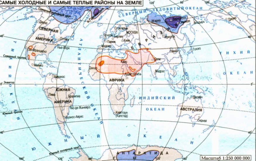 The highest temperature was marked in North America on the Mexican Highlands on 11 of August in 1933. In a shadow the temperature raised to +57.8oC. In the Death Valley, California, on the 10 of June 1913close to that high temperature +56.7oC was marked. The absolute minimum of temperature was noticed at “Vostok” station, Antarctica, in 1982. It was -89.2oC. Before it in the northern hemisphere, the lowest temperature was found. In the winter of 1938 in Oimyakon the lowing of temperature to -77.8oC was noticed.
 Life in the World Ocean.
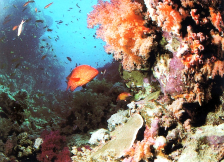 The distribution of living organisms in the surface layer depends on the climatic zone. There is little plankton in polar waters. In subarctic and subantarctic climatic belts the amount of plankton is great. Many fishes and whales come here to feed. In temperate climatic zone, there is a lot of plankton too. In subtropical and tropical belts, water is very warm and because of that is rather salty. Many corals live there. They build coral reefs and islands. There is no plankton there. Near the equator, there is usually no plankton as well, but in some places on the border of currents, you can see big amount of it. That is why many fishes live in equatorial zone
 Fishing.